
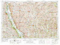
~ Nebraska City NE topo map, 1:250000 scale, 1 X 2 Degree, Historical, 1955, updated 1976
Nebraska City, Nebraska, USGS topographic map dated 1955.
Includes geographic coordinates (latitude and longitude). This topographic map is suitable for hiking, camping, and exploring, or framing it as a wall map.
Printed on-demand using high resolution imagery, on heavy weight and acid free paper, or alternatively on a variety of synthetic materials.
Topos available on paper, Waterproof, Poly, or Tyvek. Usually shipping rolled, unless combined with other folded maps in one order.
- Product Number: USGS-5564080
- Free digital map download (high-resolution, GeoPDF): Nebraska City, Nebraska (file size: 25 MB)
- Map Size: please refer to the dimensions of the GeoPDF map above
- Weight (paper map): ca. 55 grams
- Map Type: POD USGS Topographic Map
- Map Series: HTMC
- Map Verison: Historical
- Cell ID: 75003
- Scan ID: 317935
- Imprint Year: 1976
- Woodland Tint: Yes
- Visual Version Number: 1
- Aerial Photo Year: 1973
- Edit Year: 1974
- Field Check Year: 1955
- Datum: Unstated
- Map Projection: Transverse Mercator
- Map published by United States Geological Survey
- Map published by: Military, Other
- Map Language: English
- Scanner Resolution: 600 dpi
- Map Cell Name: Nebraska City
- Grid size: 1 X 2 Degree
- Date on map: 1955
- Map Scale: 1:250000
- Geographical region: Nebraska, United States
Neighboring Maps:
All neighboring USGS topo maps are available for sale online at a variety of scales.
Spatial coverage:
Topo map Nebraska City, Nebraska, covers the geographical area associated the following places:
- Skidmore - Wildwood - Bedford - Braddyville - High Creek - Shenandoah - Quitman - Siam - Willsburg (historical) - Icarid (historical) - Pinhook - Linden - Solomon - Ellenorah - Archer (historical) - Maryville - College Springs - Pickering - Farmers City - Allison - Benton - Sidney - Roberts Mobile Home Court - Wyoming - Ford City - Orrsburg - Whitesville - Watterson - South Blanchard (historical) - Ringgold (historical) - Climax - Martinsville - Nohart (historical) - Hawleyville - Stanberry - Ellston - Strahan - Coin - Gaynor - Kent - McCurry - Midway - York - Payne - Minersville - Nida (historical) - Clearfield - Pleasant Ridge - Maloy - Mount Waller - Percival - Gravity - Farragut - Bolckow - Flag Springs - Nishnabotna - Southside Trailer Park - Berlin - Marshall (historical) - Eureka - Roseberry - Todd - Coffey - Shambaugh - Union - Evona - Stanton - Adams (historical) - Guilford - Clarinda Junction (historical) - Kanosha (historical) - Merle Junction - Rosendale - Parnell - Carmack - Bethany - Gentry - Albany - Rankin - Stringtown - Empire Prairie - Barnard - Norwich - Bethesda - Peru - Oswald - Shepard (historical) - Lee (historical) - Hamburg - Milton - Mitchellville - Brooks - Paul - Hatfield - Caledonia (historical) - Bigelow - Ravenwood - Sonora - Mercer - Iveyville
- Map Area ID: AREA4140-96-94
- Northwest corner Lat/Long code: USGSNW41-96
- Northeast corner Lat/Long code: USGSNE41-94
- Southwest corner Lat/Long code: USGSSW40-96
- Southeast corner Lat/Long code: USGSSE40-94
- Northern map edge Latitude: 41
- Southern map edge Latitude: 40
- Western map edge Longitude: -96
- Eastern map edge Longitude: -94


