
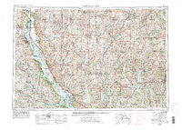
~ Nebraska City NE topo map, 1:250000 scale, 1 X 2 Degree, Historical, 1955, updated 1976
Nebraska City, Nebraska, USGS topographic map dated 1955.
Includes geographic coordinates (latitude and longitude). This topographic map is suitable for hiking, camping, and exploring, or framing it as a wall map.
Printed on-demand using high resolution imagery, on heavy weight and acid free paper, or alternatively on a variety of synthetic materials.
Topos available on paper, Waterproof, Poly, or Tyvek. Usually shipping rolled, unless combined with other folded maps in one order.
- Product Number: USGS-5564078
- Free digital map download (high-resolution, GeoPDF): Nebraska City, Nebraska (file size: 27 MB)
- Map Size: please refer to the dimensions of the GeoPDF map above
- Weight (paper map): ca. 55 grams
- Map Type: POD USGS Topographic Map
- Map Series: HTMC
- Map Verison: Historical
- Cell ID: 75003
- Scan ID: 317934
- Imprint Year: 1976
- Woodland Tint: Yes
- Aerial Photo Year: 1973
- Edit Year: 1974
- Field Check Year: 1955
- Datum: Unstated
- Map Projection: Transverse Mercator
- Map published by United States Geological Survey
- Map Language: English
- Scanner Resolution: 600 dpi
- Map Cell Name: Nebraska City
- Grid size: 1 X 2 Degree
- Date on map: 1955
- Map Scale: 1:250000
- Geographical region: Nebraska, United States
Neighboring Maps:
All neighboring USGS topo maps are available for sale online at a variety of scales.
Spatial coverage:
Topo map Nebraska City, Nebraska, covers the geographical area associated the following places:
- Gravity - Whitesville - Icarid (historical) - Lenox - Oswald - South Side Mobile Home Park - Payne - Carmack - King City - Bigelow - Southside Trailer Park - London - White Cloud - Eureka - Campbell Corner - Yancton (historical) - Barnard - Rulo - Diagonal - Beaconsfield - Preston - Salem - Braddyville - Denver - Old Pattonsburg - Craig - Graham - Siloam Springs - Holt - Peru - Clearfield - Shambaugh - Farragut - Mount Ayr - Straussville - New Market - Sheridan - Phelps City - Ellenorah - Rohrs - Thurman - Bridgeport - Norwich - Dotham - Bethesda - Kanosha (historical) - Ford City - Shepard (historical) - Hepburn - Lone Star - McPaul - McCurry - New Hampton - Hopkins - Imogene - Rea - Prohibition City - Paul - Percival - Villisca - Berlin - Brock - Orrsburg - Wanamaker - Pawnee - Wyeth - Solomon - Sonora - Skidmore - Falls City - Voyage (historical) - Martinsville - Hawleyville - Effingham - Linden - Isadora - Verdon - Burlington Junction - Maloy - Nishnabotna - Shubert - Empire Prairie - Rock Bluff (historical) - Conception Junction - Coffey - Nodaway - Brooklyn - Cypress - Minersville - Gaynor - Nichols Grove - Parnell - Guilford - Wyoming - McFall - Pattonsburg - Bethany - Humboldt - Big Lake - Athelstan
- Map Area ID: AREA4140-96-94
- Northwest corner Lat/Long code: USGSNW41-96
- Northeast corner Lat/Long code: USGSNE41-94
- Southwest corner Lat/Long code: USGSSW40-96
- Southeast corner Lat/Long code: USGSSE40-94
- Northern map edge Latitude: 41
- Southern map edge Latitude: 40
- Western map edge Longitude: -96
- Eastern map edge Longitude: -94


