
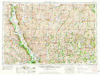
~ Nebraska City NE topo map, 1:250000 scale, 1 X 2 Degree, Historical, 1958, updated 1958
Nebraska City, Nebraska, USGS topographic map dated 1958.
Includes geographic coordinates (latitude and longitude). This topographic map is suitable for hiking, camping, and exploring, or framing it as a wall map.
Printed on-demand using high resolution imagery, on heavy weight and acid free paper, or alternatively on a variety of synthetic materials.
Topos available on paper, Waterproof, Poly, or Tyvek. Usually shipping rolled, unless combined with other folded maps in one order.
- Product Number: USGS-5564076
- Free digital map download (high-resolution, GeoPDF): Nebraska City, Nebraska (file size: 23 MB)
- Map Size: please refer to the dimensions of the GeoPDF map above
- Weight (paper map): ca. 55 grams
- Map Type: POD USGS Topographic Map
- Map Series: HTMC
- Map Verison: Historical
- Cell ID: 75003
- Scan ID: 317933
- Imprint Year: 1958
- Woodland Tint: Yes
- Field Check Year: 1955
- Datum: Unstated
- Map Projection: Transverse Mercator
- Map published by United States Geological Survey
- Map published by United States Army Corps of Engineers
- Map published by United States Army
- Map Language: English
- Scanner Resolution: 600 dpi
- Map Cell Name: Nebraska City
- Grid size: 1 X 2 Degree
- Date on map: 1958
- Map Scale: 1:250000
- Geographical region: Nebraska, United States
Neighboring Maps:
All neighboring USGS topo maps are available for sale online at a variety of scales.
Spatial coverage:
Topo map Nebraska City, Nebraska, covers the geographical area associated the following places:
- Strahan - Dawsonville - Pickering - Iona City (historical) - Pattonsburg - Possum Walk - Arkoe - Ringgold (historical) - Rohrs - Stanberry - Washington Center - Siloam Springs - Darlington - Roseberry - Irena - Glenrock - Ravenwood - Flag Springs - Thurman - New Market - Diagonal - Langdon - Nebraska City - Stringtown - Albany - Kanosha (historical) - Guss - Applewood Mobile Home Park - Oxford - Gaynor - Conway - Bingham - Allendale - Shannon City - Ellenorah - Athens (historical) - Graham - Peru - Verdon - Knowlton - Allison - Salem - Nehawka - Westboro - Southside Trailer Park - McPaul - Nodaway - Summit - High Creek - Holt - Campbell Corner - Eureka - Skidmore - Bethany - Farmers City - Icarid (historical) - Worth - Page Center - Watterson - Essex - Conception Junction - Monastery - Conception - Saint Deroin (historical) - Shepard (historical) - Salem Coffey P O and Station - Lenox - Midway - Solomon - Arago (historical) - Nohart (historical) - Mitchellville - Blanchard - Cawood - Kent - Hepburn - Straussville - Rock Bluff (historical) - Mortimer (historical) - Percival - Clearfield - Enyart - Benton - Clyde - Maryville - College Springs - Guilford - Imogene - Douglas - Brooklyn - Randolph - Shenandoah - Martinsville - Clarinda Junction (historical) - Rosendale - Adams (historical) - Gravity - Hawleyville - Archer (historical) - Clark
- Map Area ID: AREA4140-96-94
- Northwest corner Lat/Long code: USGSNW41-96
- Northeast corner Lat/Long code: USGSNE41-94
- Southwest corner Lat/Long code: USGSSW40-96
- Southeast corner Lat/Long code: USGSSE40-94
- Northern map edge Latitude: 41
- Southern map edge Latitude: 40
- Western map edge Longitude: -96
- Eastern map edge Longitude: -94


