
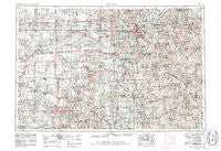
~ Lincoln NE topo map, 1:250000 scale, 1 X 2 Degree, Historical, 1955, updated 1986
Lincoln, Nebraska, USGS topographic map dated 1955.
Includes geographic coordinates (latitude and longitude). This topographic map is suitable for hiking, camping, and exploring, or framing it as a wall map.
Printed on-demand using high resolution imagery, on heavy weight and acid free paper, or alternatively on a variety of synthetic materials.
Topos available on paper, Waterproof, Poly, or Tyvek. Usually shipping rolled, unless combined with other folded maps in one order.
- Product Number: USGS-5564066
- Free digital map download (high-resolution, GeoPDF): Lincoln, Nebraska (file size: 24 MB)
- Map Size: please refer to the dimensions of the GeoPDF map above
- Weight (paper map): ca. 55 grams
- Map Type: POD USGS Topographic Map
- Map Series: HTMC
- Map Verison: Historical
- Cell ID: 68876
- Scan ID: 317928
- Imprint Year: 1986
- Woodland Tint: Yes
- Aerial Photo Year: 1978
- Edit Year: 1981
- Field Check Year: 1955
- Datum: NAD27
- Map Projection: Transverse Mercator
- Map published by United States Geological Survey
- Map published by: Military, Other
- Map Language: English
- Scanner Resolution: 600 dpi
- Map Cell Name: Lincoln
- Grid size: 1 X 2 Degree
- Date on map: 1955
- Map Scale: 1:250000
- Geographical region: Nebraska, United States
Neighboring Maps:
All neighboring USGS topo maps are available for sale online at a variety of scales.
Spatial coverage:
Topo map Lincoln, Nebraska, covers the geographical area associated the following places:
- Wilber - Pickrell - Jamaica - Lorton - Du Bois - Twin Oaks Mobile Park - Saronville - Graf (historical) - Charlestown (historical) - Filley - Wymore - Rudy - Arbor - Henderson - Verona - Louisville - Lewiston - Dorchester - Vesta - Harbour West Mobile Home Park - Daykin - Eldorado - Sawyer (historical) - Alvo - Tecumseh - Houston - Kramer - Geneva - Tangeman - Mission (historical) - Cortland - Countryside Estates - Violet (historical) - Hickman - Stoddard (historical) - West O Trailer Park - Pleasant Dale - Angus - Grover - Sprague - Steinauer - Gladstone - Cio (historical) - Virginia - York - Centerville - Beaver Crossing - Goehner - Malcolm - Odell - Belvidere - Carleton - Lanham - Garland - Hubbell - Lushton - Ellis - Hedrix - Deshler - Firth - Bethany - Grafton - Milligan - Ruskin - Woodlawn - Lincoln - Martell - Milford - Chester - Belmont - Armour (historical) - Waverly - Mayberry - Weeping Water - Hebron - Hoyle North 77 Mobile Homes - Woodlawn Estates - Steele City - Meridian (historical) - Shady Elm Mobile Home Park - Cordova - Cheney - Manley - Burr - Center Court Mobile Home Park - Swanton - Helena (historical) - Yankee Hill - Friend - Sedan - Crab Orchard - Shickley - Rockford - Camden (historical) - Williams (historical) - Hallam - Helvey - McCool Junction - Endicott - Princeton
- Map Area ID: AREA4140-98-96
- Northwest corner Lat/Long code: USGSNW41-98
- Northeast corner Lat/Long code: USGSNE41-96
- Southwest corner Lat/Long code: USGSSW40-98
- Southeast corner Lat/Long code: USGSSE40-96
- Northern map edge Latitude: 41
- Southern map edge Latitude: 40
- Western map edge Longitude: -98
- Eastern map edge Longitude: -96


