
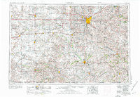
~ Lincoln NE topo map, 1:250000 scale, 1 X 2 Degree, Historical, 1955, updated 1976
Lincoln, Nebraska, USGS topographic map dated 1955.
Includes geographic coordinates (latitude and longitude). This topographic map is suitable for hiking, camping, and exploring, or framing it as a wall map.
Printed on-demand using high resolution imagery, on heavy weight and acid free paper, or alternatively on a variety of synthetic materials.
Topos available on paper, Waterproof, Poly, or Tyvek. Usually shipping rolled, unless combined with other folded maps in one order.
- Product Number: USGS-5564060
- Free digital map download (high-resolution, GeoPDF): Lincoln, Nebraska (file size: 23 MB)
- Map Size: please refer to the dimensions of the GeoPDF map above
- Weight (paper map): ca. 55 grams
- Map Type: POD USGS Topographic Map
- Map Series: HTMC
- Map Verison: Historical
- Cell ID: 68876
- Scan ID: 317925
- Imprint Year: 1976
- Woodland Tint: Yes
- Edit Year: 1966
- Field Check Year: 1955
- Datum: Unstated
- Map Projection: Transverse Mercator
- Map published by United States Army Corps of Engineers
- Map published by United States Army
- Map Language: English
- Scanner Resolution: 600 dpi
- Map Cell Name: Lincoln
- Grid size: 1 X 2 Degree
- Date on map: 1955
- Map Scale: 1:250000
- Geographical region: Nebraska, United States
Neighboring Maps:
All neighboring USGS topo maps are available for sale online at a variety of scales.
Spatial coverage:
Topo map Lincoln, Nebraska, covers the geographical area associated the following places:
- Alexandria - Pella (historical) - Staplehurst - Woodlawn Estates - Louisville - Cheney - Reynolds - Hanlon - Dorchester - Angus - Ong - Fairbury - Pine Lake - Shickley - Hoyle North 77 Mobile Homes - Ruskin - Yankee Hill - Deshler - Davenport - Cio (historical) - Berks - Stoddard (historical) - Helena (historical) - Gaslight Village - Hubbell - West Lincoln - Tangeman - Steele City - Emerald - Jansen - Cushman - Barneston - Martland - Riverside Park - Shady Elm Mobile Home Park - Pine Acre Mobile Home Park - Sutton - Harbour West Mobile Home Park - Wilber - Alvo - Lincoln - Charlestown (historical) - Bruning - Ellis - Hampton - Delta (historical) - Rudy - Tate (historical) - Seward - Crab Orchard - Dunbar - Byron - Odell - Elk Creek - Douglas - Harbine - Hedrix - Mission (historical) - Bradshaw - Swanton - Burchard - Hallam - De Witt - Graf (historical) - Tamora - Milford - Helvey - University Place - Belvidere - Marian Center - Shamrock Mobile Home Court - Pawnee City - Bennet - West O Trailer Park - Friend - Pleasant Dale - Talmage - Utica - Elmwood - Garland - Weeping Water - Eldorado - Waco - Carlisle - Unadilla - Vesta - Walton - Sedan - Wymore - Grover - Plymouth - Burress - Rockford - Ruby - Eagle - Thompson - Firth - Verona - Henderson - Tecumseh
- Map Area ID: AREA4140-98-96
- Northwest corner Lat/Long code: USGSNW41-98
- Northeast corner Lat/Long code: USGSNE41-96
- Southwest corner Lat/Long code: USGSSW40-98
- Southeast corner Lat/Long code: USGSSE40-96
- Northern map edge Latitude: 41
- Southern map edge Latitude: 40
- Western map edge Longitude: -98
- Eastern map edge Longitude: -96


