
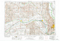
~ Fremont NE topo map, 1:250000 scale, 1 X 2 Degree, Historical, 1955, updated 1974
Fremont, Nebraska, USGS topographic map dated 1955.
Includes geographic coordinates (latitude and longitude). This topographic map is suitable for hiking, camping, and exploring, or framing it as a wall map.
Printed on-demand using high resolution imagery, on heavy weight and acid free paper, or alternatively on a variety of synthetic materials.
Topos available on paper, Waterproof, Poly, or Tyvek. Usually shipping rolled, unless combined with other folded maps in one order.
- Product Number: USGS-5564044
- Free digital map download (high-resolution, GeoPDF): Fremont, Nebraska (file size: 23 MB)
- Map Size: please refer to the dimensions of the GeoPDF map above
- Weight (paper map): ca. 55 grams
- Map Type: POD USGS Topographic Map
- Map Series: HTMC
- Map Verison: Historical
- Cell ID: 68791
- Scan ID: 317917
- Imprint Year: 1974
- Woodland Tint: Yes
- Aerial Photo Year: 1971
- Edit Year: 1971
- Field Check Year: 1955
- Datum: Unstated
- Map Projection: Transverse Mercator
- Map published by United States Geological Survey
- Map published by: Military, Other
- Map Language: English
- Scanner Resolution: 600 dpi
- Map Cell Name: Fremont
- Grid size: 1 X 2 Degree
- Date on map: 1955
- Map Scale: 1:250000
- Geographical region: Nebraska, United States
Neighboring Maps:
All neighboring USGS topo maps are available for sale online at a variety of scales.
Spatial coverage:
Topo map Fremont, Nebraska, covers the geographical area associated the following places:
- C and K Mobile Home Park - Duncan - Blencoe - Lane - Stanton - Cullom - Craig - Millard - Stromsburg - Aksarben Mobile Home Park - Coniglias Mobile Home Park - Maplewood Estates - Chalco - Genoa - Sheldonville - Saint Bernard - Rellers Park - Washington - Wann - Osceola - Little Sioux - Snyder - Surprise - Arlington - Rogers - Wahoo - Beacon View - Beemer - Durant - De Soto - Mondamin - South Broad Trailer Court - Blair - Merchiston - Ralston - Abel - Garrison - Omaha Regency - Midway Trailer Court - David City - Caradon Mobile Home Park - Debolt - Swedeburg - Waterloo - Weston - Enola - King Lake - Heber - Saint Charles - Octavia - Stanton Mobile Park - Peaceful Valley Mobile Homes - Howells - Skyline - Rising City - Riverside (historical) - Hillside Vista Trailer Court - Ashland - Morse Bluff - Gresham - River Sioux - Warnerville - Kronborg - Mercer - Kalamazoo - Lonnies Trailer Court - Nickerson - Leigh - Riverside - Papillion - Inglewood - Monterey - Bismarck - Platte Center - Ulysses - Carriage House Estates - Springfield - Lake Platte View - Riverside Park - Orum - Elkhorn - Irvington - Fairview (historical) - Westlake Mobile Home Park - Clarks - Westside Mobile Home Park - Yutan - Arizona - Humphrey - Arborville - Essen - Memphis - Winslow - Fort Calhoun - Touhy - Country Mobile Villa - Lindsay - College View Park - Portal - Country Estates Mobile Home Park
- Map Area ID: AREA4241-98-96
- Northwest corner Lat/Long code: USGSNW42-98
- Northeast corner Lat/Long code: USGSNE42-96
- Southwest corner Lat/Long code: USGSSW41-98
- Southeast corner Lat/Long code: USGSSE41-96
- Northern map edge Latitude: 42
- Southern map edge Latitude: 41
- Western map edge Longitude: -98
- Eastern map edge Longitude: -96


