
~ Ogallala NE topo map, 1:125000 scale, 30 X 30 Minute, Historical, 1900, updated 1946
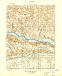
Ogallala, Nebraska, USGS topographic map dated 1900.
Includes geographic coordinates (latitude and longitude). This topographic map is suitable for hiking, camping, and exploring, or framing it as a wall map.
Printed on-demand using high resolution imagery, on heavy weight and acid free paper, or alternatively on a variety of synthetic materials.
Topos available on paper, Waterproof, Poly, or Tyvek. Usually shipping rolled, unless combined with other folded maps in one order.
- Product Number: USGS-5563916
- Free digital map download (high-resolution, GeoPDF): Ogallala, Nebraska (file size: 10 MB)
- Map Size: please refer to the dimensions of the GeoPDF map above
- Weight (paper map): ca. 55 grams
- Map Type: POD USGS Topographic Map
- Map Series: HTMC
- Map Verison: Historical
- Cell ID: 66233
- Scan ID: 317848
- Imprint Year: 1946
- Survey Year: 1897
- Datum: Unstated
- Map Projection: Unstated
- Map published by United States Geological Survey
- Map Language: English
- Scanner Resolution: 600 dpi
- Map Cell Name: Ogallala
- Grid size: 30 X 30 Minute
- Date on map: 1900
- Map Scale: 1:125000
- Geographical region: Nebraska, United States
Neighboring Maps:
All neighboring USGS topo maps are available for sale online at a variety of scales.
Spatial coverage:
Topo map Ogallala, Nebraska, covers the geographical area associated the following places:
- Lemoyne - Belmar - Broganville - L and L Mobile Home Park - Ogallala - McKeag - Martin - Beals Trailer Court - Megeath - Brule - Roscoe - Lemoyne Mobile Home Park - Keystone
- Map Area ID: AREA41.541-102-101.5
- Northwest corner Lat/Long code: USGSNW41.5-102
- Northeast corner Lat/Long code: USGSNE41.5-101.5
- Southwest corner Lat/Long code: USGSSW41-102
- Southeast corner Lat/Long code: USGSSE41-101.5
- Northern map edge Latitude: 41.5
- Southern map edge Latitude: 41
- Western map edge Longitude: -102
- Eastern map edge Longitude: -101.5


