
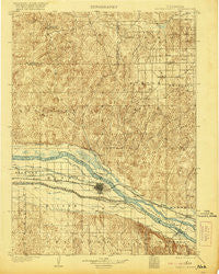
~ North Platte NE topo map, 1:125000 scale, 30 X 30 Minute, Historical, 1902, updated 1921
North Platte, Nebraska, USGS topographic map dated 1902.
Includes geographic coordinates (latitude and longitude). This topographic map is suitable for hiking, camping, and exploring, or framing it as a wall map.
Printed on-demand using high resolution imagery, on heavy weight and acid free paper, or alternatively on a variety of synthetic materials.
Topos available on paper, Waterproof, Poly, or Tyvek. Usually shipping rolled, unless combined with other folded maps in one order.
- Product Number: USGS-5563908
- Free digital map download (high-resolution, GeoPDF): North Platte, Nebraska (file size: 10 MB)
- Map Size: please refer to the dimensions of the GeoPDF map above
- Weight (paper map): ca. 55 grams
- Map Type: POD USGS Topographic Map
- Map Series: HTMC
- Map Verison: Historical
- Cell ID: 66209
- Scan ID: 317844
- Imprint Year: 1921
- Survey Year: 1899
- Datum: Unstated
- Map Projection: Unstated
- Map published by United States Geological Survey
- Map Language: English
- Scanner Resolution: 600 dpi
- Map Cell Name: North Platte
- Grid size: 30 X 30 Minute
- Date on map: 1902
- Map Scale: 1:125000
- Geographical region: Nebraska, United States
Neighboring Maps:
All neighboring USGS topo maps are available for sale online at a variety of scales.
Spatial coverage:
Topo map North Platte, Nebraska, covers the geographical area associated the following places:
- Myrtle (historical) - Beck - Bignell - Village Square - Keith - Mobile Manor - Key Estates - Stapleton - Sioux View Park - Birdwood - Green Acres Trailer Court - Tri States Trailer Court - Maxwell - North Platte
- Map Area ID: AREA41.541-101-100.5
- Northwest corner Lat/Long code: USGSNW41.5-101
- Northeast corner Lat/Long code: USGSNE41.5-100.5
- Southwest corner Lat/Long code: USGSSW41-101
- Southeast corner Lat/Long code: USGSSE41-100.5
- Northern map edge Latitude: 41.5
- Southern map edge Latitude: 41
- Western map edge Longitude: -101
- Eastern map edge Longitude: -100.5


