
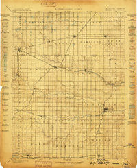
~ Hebron NE topo map, 1:125000 scale, 30 X 30 Minute, Historical, 1898
Hebron, Nebraska, USGS topographic map dated 1898.
Includes geographic coordinates (latitude and longitude). This topographic map is suitable for hiking, camping, and exploring, or framing it as a wall map.
Printed on-demand using high resolution imagery, on heavy weight and acid free paper, or alternatively on a variety of synthetic materials.
Topos available on paper, Waterproof, Poly, or Tyvek. Usually shipping rolled, unless combined with other folded maps in one order.
- Product Number: USGS-5563848
- Free digital map download (high-resolution, GeoPDF): Hebron, Nebraska (file size: 8 MB)
- Map Size: please refer to the dimensions of the GeoPDF map above
- Weight (paper map): ca. 55 grams
- Map Type: POD USGS Topographic Map
- Map Series: HTMC
- Map Verison: Historical
- Cell ID: 65664
- Scan ID: 317811
- Survey Year: 1894
- Datum: Unstated
- Map Projection: Unstated
- Map published by United States Geological Survey
- Map Language: English
- Scanner Resolution: 600 dpi
- Map Cell Name: Hebron
- Grid size: 30 X 30 Minute
- Date on map: 1898
- Map Scale: 1:125000
- Geographical region: Nebraska, United States
Neighboring Maps:
All neighboring USGS topo maps are available for sale online at a variety of scales.
Spatial coverage:
Topo map Hebron, Nebraska, covers the geographical area associated the following places:
- Belvidere - Carleton - Sedan - Chester - Byron - Angus - Deshler - Oak - Davenport - Oak Mill - Strang - Ong - Martland - Nora - Hardy - Bruning - Ruskin - Shickley - Edgar - Stoddard (historical) - Carlisle - Hebron
- Map Area ID: AREA40.540-98-97.5
- Northwest corner Lat/Long code: USGSNW40.5-98
- Northeast corner Lat/Long code: USGSNE40.5-97.5
- Southwest corner Lat/Long code: USGSSW40-98
- Southeast corner Lat/Long code: USGSSE40-97.5
- Northern map edge Latitude: 40.5
- Southern map edge Latitude: 40
- Western map edge Longitude: -98
- Eastern map edge Longitude: -97.5


