
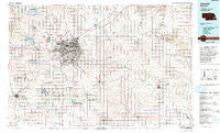
~ Lincoln NE topo map, 1:100000 scale, 30 X 60 Minute, Historical, 1986, updated 1994
Lincoln, Nebraska, USGS topographic map dated 1986.
Includes geographic coordinates (latitude and longitude). This topographic map is suitable for hiking, camping, and exploring, or framing it as a wall map.
Printed on-demand using high resolution imagery, on heavy weight and acid free paper, or alternatively on a variety of synthetic materials.
Topos available on paper, Waterproof, Poly, or Tyvek. Usually shipping rolled, unless combined with other folded maps in one order.
- Product Number: USGS-5563722
- Free digital map download (high-resolution, GeoPDF): Lincoln, Nebraska (file size: 29 MB)
- Map Size: please refer to the dimensions of the GeoPDF map above
- Weight (paper map): ca. 55 grams
- Map Type: POD USGS Topographic Map
- Map Series: HTMC
- Map Verison: Historical
- Cell ID: 67848
- Scan ID: 317745
- Imprint Year: 1994
- Woodland Tint: Yes
- Photo Inspection Year: 1988
- Aerial Photo Year: 1988
- Edit Year: 1986
- Datum: NAD27
- Map Projection: Universal Transverse Mercator
- Map published by United States Geological Survey
- Map Language: English
- Scanner Resolution: 600 dpi
- Map Cell Name: Lincoln
- Grid size: 30 X 60 Minute
- Date on map: 1986
- Map Scale: 1:100000
- Geographical region: Nebraska, United States
Neighboring Maps:
All neighboring USGS topo maps are available for sale online at a variety of scales.
Spatial coverage:
Topo map Lincoln, Nebraska, covers the geographical area associated the following places:
- Emerald - Countryside Estates - Havelock - Denton - Contempo-Lincoln Mobile Home Park - Camden (historical) - Bennet - Holland - Kramer - Gaslight Village - Cortland - Avoca - Woodlawn Estates - Woodlawn - Harbour West Mobile Home Park - Raymond - Arbor - Hickman - Unadilla - Murdock - Pella (historical) - Prairie Home - Shestak - Marian Center - Shamrock Mobile Home Court - Walton - Elmwood - Lorton - Lincoln - Cio (historical) - Pine Acre Mobile Home Park - Pleasant Dale - Yankee Hill - Pine Lake - Rokeby - Shady Elm Mobile Home Park - Saltillo - Weeping Water - Greenwood - Cook - Roca - Centerville - Huskerville - Manley - Wabash - Berks - Mark IV Estates - University Place - Garland - Otoe - Center Court Mobile Home Park - Belmont - Sprague - Jamaica - West O Trailer Park - Davey - Waverly - Hanlon - Helena (historical) - Panama - Dunbar - Delta (historical) - Palmyra - Cheney - Bethany - Burr - Princeton - West Lincoln - Louisville - Malcolm - Tangeman - Martell - Talmage - Crete - Cushman - Alvo - Eagle - Firth - Hallam - Douglas - College View - Syracuse
- Map Area ID: AREA4140.5-97-96
- Northwest corner Lat/Long code: USGSNW41-97
- Northeast corner Lat/Long code: USGSNE41-96
- Southwest corner Lat/Long code: USGSSW40.5-97
- Southeast corner Lat/Long code: USGSSE40.5-96
- Northern map edge Latitude: 41
- Southern map edge Latitude: 40.5
- Western map edge Longitude: -97
- Eastern map edge Longitude: -96


