
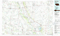
~ Falls City NE topo map, 1:100000 scale, 30 X 60 Minute, Historical, 1986, updated 1986
Falls City, Nebraska, USGS topographic map dated 1986.
Includes geographic coordinates (latitude and longitude). This topographic map is suitable for hiking, camping, and exploring, or framing it as a wall map.
Printed on-demand using high resolution imagery, on heavy weight and acid free paper, or alternatively on a variety of synthetic materials.
Topos available on paper, Waterproof, Poly, or Tyvek. Usually shipping rolled, unless combined with other folded maps in one order.
- Product Number: USGS-5563684
- Free digital map download (high-resolution, GeoPDF): Falls City, Nebraska (file size: 18 MB)
- Map Size: please refer to the dimensions of the GeoPDF map above
- Weight (paper map): ca. 55 grams
- Map Type: POD USGS Topographic Map
- Map Series: HTMC
- Map Verison: Historical
- Cell ID: 72636
- Scan ID: 317725
- Imprint Year: 1986
- Woodland Tint: Yes
- Aerial Photo Year: 1982
- Edit Year: 1986
- Datum: NAD27
- Map Projection: Universal Transverse Mercator
- Planimetric: Yes
- Map published by United States Geological Survey
- Map Language: English
- Scanner Resolution: 600 dpi
- Map Cell Name: Falls City
- Grid size: 30 X 60 Minute
- Date on map: 1986
- Map Scale: 1:100000
- Geographical region: Nebraska, United States
Neighboring Maps:
All neighboring USGS topo maps are available for sale online at a variety of scales.
Spatial coverage:
Topo map Falls City, Nebraska, covers the geographical area associated the following places:
- Dotham - Milton - Preston - Sonora - Watson - Phelps City - Napier - Stella - Johnson - Glenrock - Craig - Skidmore - Arago (historical) - Graham - Burlington Junction - Nichols Grove - Shubert - Howe - Nemaha - Corning - Verdon - Possum Walk - London - York - Dawsonville - Rulo - Southside Trailer Park - Archer (historical) - Terrace Mobile Home Park - Brownville - Yancton (historical) - Williamsville (historical) - Brock - Falls City - Roseberry - Kings Grove (historical) - Auburn - Fortescue - Tarkio - Saint Deroin (historical) - New Point - Campbell Corner - Lone Corner - Salem - Nishnabotna - Rock Port - Mound City - Langdon - Dawson - Nim City - Nohart (historical) - Fairfax - Humboldt - Maitland - Linden - Rohrs - Bigelow - Straussville - Oswald - Quitman - Big Lake - Athens (historical) - Peru - Barada
- Map Area ID: AREA40.540-96-95
- Northwest corner Lat/Long code: USGSNW40.5-96
- Northeast corner Lat/Long code: USGSNE40.5-95
- Southwest corner Lat/Long code: USGSSW40-96
- Southeast corner Lat/Long code: USGSSE40-95
- Northern map edge Latitude: 40.5
- Southern map edge Latitude: 40
- Western map edge Longitude: -96
- Eastern map edge Longitude: -95


