
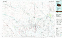
~ Burwell NE topo map, 1:100000 scale, 30 X 60 Minute, Historical, 1985, updated 1985
Burwell, Nebraska, USGS topographic map dated 1985.
Includes geographic coordinates (latitude and longitude). This topographic map is suitable for hiking, camping, and exploring, or framing it as a wall map.
Printed on-demand using high resolution imagery, on heavy weight and acid free paper, or alternatively on a variety of synthetic materials.
Topos available on paper, Waterproof, Poly, or Tyvek. Usually shipping rolled, unless combined with other folded maps in one order.
- Product Number: USGS-5563650
- Free digital map download (high-resolution, GeoPDF): Burwell, Nebraska (file size: 18 MB)
- Map Size: please refer to the dimensions of the GeoPDF map above
- Weight (paper map): ca. 55 grams
- Map Type: POD USGS Topographic Map
- Map Series: HTMC
- Map Verison: Historical
- Cell ID: 67204
- Scan ID: 317709
- Imprint Year: 1985
- Woodland Tint: Yes
- Aerial Photo Year: 1981
- Edit Year: 1985
- Datum: NAD27
- Map Projection: Universal Transverse Mercator
- Planimetric: Yes
- Map published by United States Geological Survey
- Map Language: English
- Scanner Resolution: 600 dpi
- Map Cell Name: Burwell
- Grid size: 30 X 60 Minute
- Date on map: 1985
- Map Scale: 1:100000
- Geographical region: Nebraska, United States
Neighboring Maps:
All neighboring USGS topo maps are available for sale online at a variety of scales.
Spatial coverage:
Topo map Burwell, Nebraska, covers the geographical area associated the following places:
- Elton (historical) - Mikes Meadows - Geranium (historical) - Willow Springs (historical) - Round Valley - Comstock - Wescott - Burwell - New Helena - Taylor - Almeria - Anselmo - Blaine Center (historical) - Milburn - Deverre - Elyria - Cummings Park (historical) - Rainbow Trailer Court - West Union (historical) - Aggies Acres - Brewster - Sargent - Gates - Walworth - Dale (historical) - Kent (historical) - Lillian
- Map Area ID: AREA4241.5-100-99
- Northwest corner Lat/Long code: USGSNW42-100
- Northeast corner Lat/Long code: USGSNE42-99
- Southwest corner Lat/Long code: USGSSW41.5-100
- Southeast corner Lat/Long code: USGSSE41.5-99
- Northern map edge Latitude: 42
- Southern map edge Latitude: 41.5
- Western map edge Longitude: -100
- Eastern map edge Longitude: -99


