
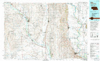
~ Blair NE topo map, 1:100000 scale, 30 X 60 Minute, Historical, 1986, updated 1994
Blair, Nebraska, USGS topographic map dated 1986.
Includes geographic coordinates (latitude and longitude). This topographic map is suitable for hiking, camping, and exploring, or framing it as a wall map.
Printed on-demand using high resolution imagery, on heavy weight and acid free paper, or alternatively on a variety of synthetic materials.
Topos available on paper, Waterproof, Poly, or Tyvek. Usually shipping rolled, unless combined with other folded maps in one order.
- Product Number: USGS-5563646
- Free digital map download (high-resolution, GeoPDF): Blair, Nebraska (file size: 28 MB)
- Map Size: please refer to the dimensions of the GeoPDF map above
- Weight (paper map): ca. 55 grams
- Map Type: POD USGS Topographic Map
- Map Series: HTMC
- Map Verison: Historical
- Cell ID: 67149
- Scan ID: 317707
- Imprint Year: 1994
- Woodland Tint: Yes
- Photo Inspection Year: 1988
- Aerial Photo Year: 1981
- Edit Year: 1986
- Datum: NAD27
- Map Projection: Universal Transverse Mercator
- Map published by United States Geological Survey
- Map Language: English
- Scanner Resolution: 600 dpi
- Map Cell Name: Blair
- Grid size: 30 X 60 Minute
- Date on map: 1986
- Map Scale: 1:100000
- Geographical region: Nebraska, United States
Neighboring Maps:
All neighboring USGS topo maps are available for sale online at a variety of scales.
Spatial coverage:
Topo map Blair, Nebraska, covers the geographical area associated the following places:
- Modale - Oakland - Monterey - Telbasta - Arizona - Webster - Admah (historical) - Scribner - Mondamin - Blair - Westside Mobile Home Park - Nickerson - Beemer - Uehling - Craig - Orum - Glencoe (historical) - Bismarck (historical) - Bertha - Olean - Riverside (historical) - Essen - Argo (historical) - Blencoe - Lyons - Country Estates Mobile Home Park - Bismarck - Saint Charles - Herman - Green Acres Mobile Home Community - Tekamah - Wisner - Hooper - Snyder - West Point - Winslow - River Sioux - Fontanelle - Little Sioux - Dodge - Crowell - Aloys
- Map Area ID: AREA4241.5-97-96
- Northwest corner Lat/Long code: USGSNW42-97
- Northeast corner Lat/Long code: USGSNE42-96
- Southwest corner Lat/Long code: USGSSW41.5-97
- Southeast corner Lat/Long code: USGSSE41.5-96
- Northern map edge Latitude: 42
- Southern map edge Latitude: 41.5
- Western map edge Longitude: -97
- Eastern map edge Longitude: -96


