
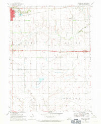
~ Aurora East NE topo map, 1:24000 scale, 7.5 X 7.5 Minute, Historical, 1968, updated 1971
Aurora East, Nebraska, USGS topographic map dated 1968.
Includes geographic coordinates (latitude and longitude). This topographic map is suitable for hiking, camping, and exploring, or framing it as a wall map.
Printed on-demand using high resolution imagery, on heavy weight and acid free paper, or alternatively on a variety of synthetic materials.
Topos available on paper, Waterproof, Poly, or Tyvek. Usually shipping rolled, unless combined with other folded maps in one order.
- Product Number: USGS-5559765
- Free digital map download (high-resolution, GeoPDF): Aurora East, Nebraska (file size: 8 MB)
- Map Size: please refer to the dimensions of the GeoPDF map above
- Weight (paper map): ca. 55 grams
- Map Type: POD USGS Topographic Map
- Map Series: HTMC
- Map Verison: Historical
- Cell ID: 1885
- Scan ID: 315743
- Imprint Year: 1971
- Woodland Tint: Yes
- Aerial Photo Year: 1964
- Survey Year: 1968
- Datum: NAD27
- Map Projection: Polyconic
- Map published by United States Geological Survey
- Map Language: English
- Scanner Resolution: 600 dpi
- Map Cell Name: Aurora East
- Grid size: 7.5 X 7.5 Minute
- Date on map: 1968
- Map Scale: 1:24000
- Geographical region: Nebraska, United States
Neighboring Maps:
All neighboring USGS topo maps are available for sale online at a variety of scales.
Spatial coverage:
Topo map Aurora East, Nebraska, covers the geographical area associated the following places:
- Alice M Farr Library - Interchange 338 - Election Precinct 3 - Plainsman Museum - Aurora Country Club - Peetzke Reservoir - Township of Beaver - First Evangelical Lutheran Church - Troester Federal Waterfowl Production Area - Nelson Federal Waterfowl Production Area - Youst Cemetery - Peetzke Dam - Salem Cemetery - Sallans Chiropractic Clinic - Interchange 332 - Hampton Cemetery - Bergeson Basin - Pintail State Wildlife Management Area - Township of Aurora - Edgerton Educational Center - Stone School (historical)
- Map Area ID: AREA40.87540.75-98-97.875
- Northwest corner Lat/Long code: USGSNW40.875-98
- Northeast corner Lat/Long code: USGSNE40.875-97.875
- Southwest corner Lat/Long code: USGSSW40.75-98
- Southeast corner Lat/Long code: USGSSE40.75-97.875
- Northern map edge Latitude: 40.875
- Southern map edge Latitude: 40.75
- Western map edge Longitude: -98
- Eastern map edge Longitude: -97.875


