
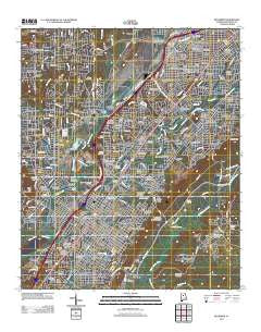
~ Bessemer AL topo map, 1:24000 scale, 7.5 X 7.5 Minute, Historical, 2011
Bessemer, Alabama, USGS topographic map dated 2011.
Includes geographic coordinates (latitude and longitude). This topographic map is suitable for hiking, camping, and exploring, or framing it as a wall map.
Printed on-demand using high resolution imagery, on heavy weight and acid free paper, or alternatively on a variety of synthetic materials.
Topos available on paper, Waterproof, Poly, or Tyvek. Usually shipping rolled, unless combined with other folded maps in one order.
- Product Number: USGS-5559477
- Free digital map download (high-resolution, GeoPDF): Bessemer, Alabama (file size: 28 MB)
- Map Size: please refer to the dimensions of the GeoPDF map above
- Weight (paper map): ca. 55 grams
- Map Type: POD USGS Topographic Map
- Map Series: US Topo
- Map Verison: Historical
- Cell ID: 3512
- Datum: North American Datum of 1983
- Map Projection: Transverse Mercator
- Map Cell Name: Bessemer
- Grid size: 7.5 X 7.5 Minute
- Date on map: 2011
- Map Scale: 1:24000
- Geographical region: Alabama, United States
Neighboring Maps:
All neighboring USGS topo maps are available for sale online at a variety of scales.
Spatial coverage:
Topo map Bessemer, Alabama, covers the geographical area associated the following places:
- Brownville - North Highlands - Ensley Junction - Bon-Air - Westfield - West Lake Highlands - Belwood - Jones Valley - Ware - Roosevelt - Rutledge Springs - Wilkes - Bush - Park Place - Wheeling Crossroad - Forest Hills - Industrial City - Wenonah - Oak Hills - New Village - Collins - Pleasant Acres - Harlem Heights - Longbrook Estates - Anns Trailer Court - Avalon Park - Hudson Gardens - Monte-Sano - Park Courts - Fairfield - Brooklane Place - Hillman - Bessemer Gardens - Bessemer - Broadmoor - Blue Creek Junction - Martins - Belle Haven - Jonesboro - Pineland Park - Bessemer Junction - Cedarbrook Forest - Woodward Estates - Roosevelt-Cairo Village - Glenview - Winetka - Fairfield Village - Woodward Junction - Gordon Heights - Madison - Grasselli - Woodward - Garywood - Midfield - Ivanhoe - Dolonar - Brighton - Tarpley - Old Jonesboro - Valhalla - Hudson Grove - Glen Oaks - Minniesville - Dolomite - Skyview - Smith Highlands - Hillman Park - Bessemer Homestead - East Brighton - Central Park Highlands - Brickyard Junction - Fairfield Highlands - Rosemont - Pleasant Grove Estates - Hueytown - Cottage Hill - Woodmont - Crescent Heights - Oakwood - West Fairfield - Cloverdale - Glen Hills - Interurban Heights - Pauls Hill - Shady Brook Mobile Home Park - Sloss - Pleasant Grove - Phoenixville - Green Acres - Hillman Gardens - Thomas Acres - Walnut Grove - Highland Forest - Dolonar Junction - Vineland Park - Hueytown Crest - Lipscomb - Lakewood Estate - Muscoda - Duncan
- Map Area ID: AREA33.533.375-87-86.875
- Northwest corner Lat/Long code: USGSNW33.5-87
- Northeast corner Lat/Long code: USGSNE33.5-86.875
- Southwest corner Lat/Long code: USGSSW33.375-87
- Southeast corner Lat/Long code: USGSSE33.375-86.875
- Northern map edge Latitude: 33.5
- Southern map edge Latitude: 33.375
- Western map edge Longitude: -87
- Eastern map edge Longitude: -86.875


