
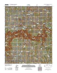
~ Buckhorn Mountain AZ topo map, 1:24000 scale, 7.5 X 7.5 Minute, Historical, 2011
Buckhorn Mountain, Arizona, USGS topographic map dated 2011.
Includes geographic coordinates (latitude and longitude). This topographic map is suitable for hiking, camping, and exploring, or framing it as a wall map.
Printed on-demand using high resolution imagery, on heavy weight and acid free paper, or alternatively on a variety of synthetic materials.
Topos available on paper, Waterproof, Poly, or Tyvek. Usually shipping rolled, unless combined with other folded maps in one order.
- Product Number: USGS-5559023
- Free digital map download (high-resolution, GeoPDF): Buckhorn Mountain, Arizona (file size: 23 MB)
- Map Size: please refer to the dimensions of the GeoPDF map above
- Weight (paper map): ca. 55 grams
- Map Type: POD USGS Topographic Map
- Map Series: US Topo
- Map Verison: Historical
- Cell ID: 5934
- Datum: North American Datum of 1983
- Map Projection: Transverse Mercator
- Map Cell Name: Buckhorn Mountain
- Grid size: 7.5 X 7.5 Minute
- Date on map: 2011
- Map Scale: 1:24000
- Geographical region: Arizona, United States
Neighboring Maps:
All neighboring USGS topo maps are available for sale online at a variety of scales.
Spatial coverage:
Topo map Buckhorn Mountain, Arizona, covers the geographical area associated the following places:
- Oak Hill Draw - Painted Tank Number Two - Pasture Tank - Horse Pasture Tank - North Fork Long Canyon - Juniper Flat Tank - Sandrock Draw Tank - Sandrock Pasture - Petes Tank - Turkey Tank - Rim Tank - Indian Flat - Twin Buttes - Twin Buttes Tank - Clear Creek Number Three Spring - Lookout Tank - Oak Hill - Tule Canyon - Cash Tank - Lone Pine Tank - Oak Hill Tank Number One - Buckhorn Tank Number Three - Salmon Lake Butte - Macks Tank Number Two - Bessie Tank - Cedar Flat Tank - Tule Butte - Outside Tank - Painted Tank Number One - Windmill Tank - Sandrock Tank - Home Tank Number Two - Salmon Lake Basin - Tank Number Two - Macks Tank Number One - Knob Tank - Salmon Lake Tank - Cedar Flat - Black Mountain Canyon Tank - Buckhorn Tank Number One - Maverick Basin Tank - Buckhorn Ranch - Maverick Basin - Home Tank Draw - Ernies Tank - Tanque Aloma - Upper Tank Draw - Red Hill Tank - Buckhorn Mountain - Red Hill - Section Five Tank - Bald Hill Tank Number One - Sugarloaf Tank - Clear Creek Number Four Spring - Loma Tank - Rock Tank - Barrow Tank - Mud Tank Number Two - Indian Flat Tank Number Two - Buckhorn Tank Number Four - Buckhorn Slope Tank - Bull Hole - Sugarloaf - Meadow Canyon - Meadow Canyon Tank - Rim Tank Basin - Rim Tank - Buckhorn Tank Number Five - Big Spring - Salmon Lake - Apron Tank - Buckhorn Tank Number Two - Cabin Tank - Home Tank Number One - V Lazy Y Cabin
- Map Area ID: AREA34.62534.5-111.625-111.5
- Northwest corner Lat/Long code: USGSNW34.625-111.625
- Northeast corner Lat/Long code: USGSNE34.625-111.5
- Southwest corner Lat/Long code: USGSSW34.5-111.625
- Southeast corner Lat/Long code: USGSSE34.5-111.5
- Northern map edge Latitude: 34.625
- Southern map edge Latitude: 34.5
- Western map edge Longitude: -111.625
- Eastern map edge Longitude: -111.5


