
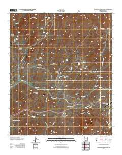
~ Picketpost Mountain AZ topo map, 1:24000 scale, 7.5 X 7.5 Minute, Historical, 2011
Picketpost Mountain, Arizona, USGS topographic map dated 2011.
Includes geographic coordinates (latitude and longitude). This topographic map is suitable for hiking, camping, and exploring, or framing it as a wall map.
Printed on-demand using high resolution imagery, on heavy weight and acid free paper, or alternatively on a variety of synthetic materials.
Topos available on paper, Waterproof, Poly, or Tyvek. Usually shipping rolled, unless combined with other folded maps in one order.
- Product Number: USGS-5558987
- Free digital map download (high-resolution, GeoPDF): Picketpost Mountain, Arizona (file size: 24 MB)
- Map Size: please refer to the dimensions of the GeoPDF map above
- Weight (paper map): ca. 55 grams
- Map Type: POD USGS Topographic Map
- Map Series: US Topo
- Map Verison: Historical
- Cell ID: 35028
- Datum: North American Datum of 1983
- Map Projection: Transverse Mercator
- Map Cell Name: Picketpost Mountain
- Grid size: 7.5 X 7.5 Minute
- Date on map: 2011
- Map Scale: 1:24000
- Geographical region: Arizona, United States
Neighboring Maps:
All neighboring USGS topo maps are available for sale online at a variety of scales.
Spatial coverage:
Topo map Picketpost Mountain, Arizona, covers the geographical area associated the following places:
- Roblas Butte - Arnett Creek - Byous Spring - Picketpost Mountain Research Natural Area - Perlite Spring - Peacock Canyon - Highway Tank - Hewitt Ridge - Rebel Tank - East Fork Roblas Canyon - Alamo Canyon - Gonzales Tank - Gonzales Pass Canyon - Roblas Windmill - Bomboy Mine - Millsite Canyon - Happy Camp Canyon - Midway Tank - Reymert Wash - Rattlesnake Spring - Superior Municipal Airport - Rice Water Canyon - Queens Station - Roblas Well - Campsite Spring - Hewitt Station - Old Pinal Townsite - Telegraph Canyon - Queen Creek Bridge - Highway Tank - Roblas Canyon - Thompson Spring - Reavis Trail Canyon - Quail Spring - Wood Camp Canyon - Byous Butte - Millsite Spring - Byous Windmill - Thompson Arboretum - Picketpost Mountain - Dugan Tank - Lower Railroad Spring - Bear Tank Canyon - Potts Canyon - Superior Dump - Vallies Well - Cottonwood Canyon - Silver King Wash - Preston Well - Canyon Spring - Millsite Headquarters - Gonzales Pass - Hewitt Canyon - Negro Head Spring - Barnett Camp - Happy Camp - Picketpost Inn - Javelina Tank - Hewitt Canyon Natural Arch - Benson Spring Canyon - Whitford Canyon - Nobel Well - Perlite Mine - Boyce Thompson Arboretum - Arnett Canyon - Happy Camp Spring - Reymert Well - Benson Spring - Arboretum Tank
- Map Area ID: AREA33.37533.25-111.25-111.125
- Northwest corner Lat/Long code: USGSNW33.375-111.25
- Northeast corner Lat/Long code: USGSNE33.375-111.125
- Southwest corner Lat/Long code: USGSSW33.25-111.25
- Southeast corner Lat/Long code: USGSSE33.25-111.125
- Northern map edge Latitude: 33.375
- Southern map edge Latitude: 33.25
- Western map edge Longitude: -111.25
- Eastern map edge Longitude: -111.125


