
~ Haunted Canyon AZ topo map, 1:24000 scale, 7.5 X 7.5 Minute, Historical, 2011
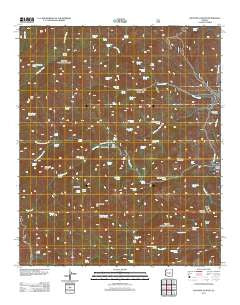
Haunted Canyon, Arizona, USGS topographic map dated 2011.
Includes geographic coordinates (latitude and longitude). This topographic map is suitable for hiking, camping, and exploring, or framing it as a wall map.
Printed on-demand using high resolution imagery, on heavy weight and acid free paper, or alternatively on a variety of synthetic materials.
Topos available on paper, Waterproof, Poly, or Tyvek. Usually shipping rolled, unless combined with other folded maps in one order.
- Product Number: USGS-5558975
- Free digital map download (high-resolution, GeoPDF): Haunted Canyon, Arizona (file size: 27 MB)
- Map Size: please refer to the dimensions of the GeoPDF map above
- Weight (paper map): ca. 55 grams
- Map Type: POD USGS Topographic Map
- Map Series: US Topo
- Map Verison: Historical
- Cell ID: 19674
- Datum: North American Datum of 1983
- Map Projection: Transverse Mercator
- Map Cell Name: Haunted Canyon
- Grid size: 7.5 X 7.5 Minute
- Date on map: 2011
- Map Scale: 1:24000
- Geographical region: Arizona, United States
Neighboring Maps:
All neighboring USGS topo maps are available for sale online at a variety of scales.
Spatial coverage:
Topo map Haunted Canyon, Arizona, covers the geographical area associated the following places:
- Brushy Spring - Brushy Spring - BM Spring - Paradise Spring - Oak Spring - Pinto Spring - Burro Spring - Iron House Spring - Rock Spring - Haunted Canyon - Eastwater Canyon - Tony Ranch - Kennedy Ranch - Kennedy Spring - J K Mountain - Bootlegger Trap Spring - Coon Spring - Wood Creek Spring - Musk Hog Spring - Ninetysix Spring - Powers Gulch - Flat Rock Spring - Willow Spring Number Two - Fifty Dollar Spring - Horrell Creek - Tony Ranch Spring - Bear Thicket Creek - Haunted Canyon Spring - Miles Ranch Trailhead - Limestone Spring - West Fork Pinto Creek - Sawtooth Ridge - Oak Flat Spring - House Rock Spring - Yellow Jacket Spring - West Spring - Rock Spring - Sheep Camp Spring - Little Mud Spring - Case Knife Spring - Bath Tub Spring - Mountain Spring - Sherry Spring - Gold Gulch - Lower Champaign Spring - Mowing Machine Spring - Spencer Spring Creek - Bull Basin - Cherry Spring - Grapevine Spring - Apache Spring - Little Well - Blue Spring - Government Hill - Oak Spring - Jerky Spring - Red Rock Spring - Cuff Button Spring - Sycamore Spring - Bootlegger Spring - Wood Creek - Cement Spring - Jones Water Spring - Baldwin Spring - Pinto Peak - Rock Creek - Upper Haunted Canyon Spring - Bear Spring
- Map Area ID: AREA33.533.375-111.125-111
- Northwest corner Lat/Long code: USGSNW33.5-111.125
- Northeast corner Lat/Long code: USGSNE33.5-111
- Southwest corner Lat/Long code: USGSSW33.375-111.125
- Southeast corner Lat/Long code: USGSSE33.375-111
- Northern map edge Latitude: 33.5
- Southern map edge Latitude: 33.375
- Western map edge Longitude: -111.125
- Eastern map edge Longitude: -111


