
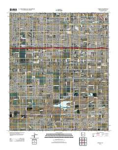
~ Fowler AZ topo map, 1:24000 scale, 7.5 X 7.5 Minute, Historical, 2011
Fowler, Arizona, USGS topographic map dated 2011.
Includes geographic coordinates (latitude and longitude). This topographic map is suitable for hiking, camping, and exploring, or framing it as a wall map.
Printed on-demand using high resolution imagery, on heavy weight and acid free paper, or alternatively on a variety of synthetic materials.
Topos available on paper, Waterproof, Poly, or Tyvek. Usually shipping rolled, unless combined with other folded maps in one order.
- Product Number: USGS-5558293
- Free digital map download (high-resolution, GeoPDF): Fowler, Arizona (file size: 24 MB)
- Map Size: please refer to the dimensions of the GeoPDF map above
- Weight (paper map): ca. 55 grams
- Map Type: POD USGS Topographic Map
- Map Series: US Topo
- Map Verison: Historical
- Cell ID: 16163
- Datum: North American Datum of 1983
- Map Projection: Transverse Mercator
- Map Cell Name: Fowler
- Grid size: 7.5 X 7.5 Minute
- Date on map: 2011
- Map Scale: 1:24000
- Geographical region: Arizona, United States
Neighboring Maps:
All neighboring USGS topo maps are available for sale online at a variety of scales.
Spatial coverage:
Topo map Fowler, Arizona, covers the geographical area associated the following places:
- Lazy Daze Mobile Home Park - Western Acres Mobile Home Park - Santa Maria - Cartwright - Sunburst Homes - Willows West - Trailer Corral - Estrella Shadows Mobile Home Park - Sunscape Homes - Centura West - Parkwood - Catalina Village - Cataline Village Mobile Home Park - Michigan Trailer Park - Alhambra - Capri Village - Maryvale Terrace - County Fair West - Lazy T Mobile Home Park - Young America Homes - Capri Mobile Home Park - Westridge Park - Sunrise Terrace - Legend Estates - Desert Gem Mobile Home Park - Blue Bell Mobile Home Park - Western Palms Mobile Home Community - Phoenix Acres Trailer Park - La Terraza - Rose Lane Trailer Park - Fowler - Stagecoach Trailer Park - Out West Trailer Park - Hidden Acres Mobile Home Park
- Map Area ID: AREA33.533.375-112.25-112.125
- Northwest corner Lat/Long code: USGSNW33.5-112.25
- Northeast corner Lat/Long code: USGSNE33.5-112.125
- Southwest corner Lat/Long code: USGSSW33.375-112.25
- Southeast corner Lat/Long code: USGSSE33.375-112.125
- Northern map edge Latitude: 33.5
- Southern map edge Latitude: 33.375
- Western map edge Longitude: -112.25
- Eastern map edge Longitude: -112.125


