
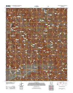
~ Weavers Needle AZ topo map, 1:24000 scale, 7.5 X 7.5 Minute, Historical, 2011
Weavers Needle, Arizona, USGS topographic map dated 2011.
Includes geographic coordinates (latitude and longitude). This topographic map is suitable for hiking, camping, and exploring, or framing it as a wall map.
Printed on-demand using high resolution imagery, on heavy weight and acid free paper, or alternatively on a variety of synthetic materials.
Topos available on paper, Waterproof, Poly, or Tyvek. Usually shipping rolled, unless combined with other folded maps in one order.
- Product Number: USGS-5557949
- Free digital map download (high-resolution, GeoPDF): Weavers Needle, Arizona (file size: 27 MB)
- Map Size: please refer to the dimensions of the GeoPDF map above
- Weight (paper map): ca. 55 grams
- Map Type: POD USGS Topographic Map
- Map Series: US Topo
- Map Verison: Historical
- Cell ID: 47878
- Datum: North American Datum of 1983
- Map Projection: Transverse Mercator
- Map Cell Name: Weavers Needle
- Grid size: 7.5 X 7.5 Minute
- Date on map: 2011
- Map Scale: 1:24000
- Geographical region: Arizona, United States
Neighboring Maps:
All neighboring USGS topo maps are available for sale online at a variety of scales.
Spatial coverage:
Topo map Weavers Needle, Arizona, covers the geographical area associated the following places:
- Upper LaBarge Box Canyon - Needle Trail - Peralta Canyon Camp - Peters Trail - Tortilla Trailhead - Holmes Spring - Burro Basin - Charlebois Canyon - Tortilla Well - Miller Spring - Oak Spring - Barks Canyon - Peralta Canyon - Miller Mines - Whiskey Spring - Picacho Butte - Black Mountain - Williams Camp - Charlebois Spring - Marsh Valley - Bluff Spring Mountain Canyon - Whitlow Corral - Whiskey Spring Trail - Brads Canyon - Horse Camp Spring - Music Mountain - Peralta Canyon Campground - Terrapin Pass - Tortilla Ranch - Bluff Spring Mountain Spring - Coffee Flat Mountain - Deerhorn Spring - Red Tanks Divide - Cedar Basin Canyon - White Rock Corral - Kane Spring - LaBarge Spring - Indian Spring - Tortilla Mountain - Night Hawk Spring - Quarter Circle U Ranch - Horse Camp Basin - Coffee Flat - Reeds Water - Indian Spring Number One - Miners Summit - Dripping Spring - Lost Dutch Spring - Red Tanks Trail - Musk Hog Canyon - Brads Water - Herman Mountain - Miners Trail - Crystal Spring - Lost Dutch Canyon - Canyon Spring - Trap Canyon - Cedar Basin - Buzzard Roost - Sheep Mountain Spring - Squaw Canyon - Reeds Camp - Peralta Trailhead - Weavers Needle - Bluff Saddle - Miners Needle - Fraser Canyon - Music Canyon - Dogie Spring - Upper LaBarge Spring - Whiskey Spring Canyon - Miller Tunnel Number One Spring - Trap Canyon Spring - Red Tanks Canyon - Bluff Spring - Piñon Camp - Little Hawk Spring - Labarge Spring Number Two - Coffee Flat Trail - Randolph Canyon - Clover Spring - Horse Ridge - Music Canyon Spring - Bluff Spring Canyon - Dutchmans Trail - Barkley Basin - Carney Springs Campground - Dacite Cliffs Mine - Cave Trail - Carney Spring - Dacite Cliffs - Fremont Saddle - Peralta Spring - Dons Camp - Coffee Flat Canyon - Bluff Spring Mountain - Peralta Trail - Malapais Mountain - Peters Mesa - Miners Canyon
- Map Area ID: AREA33.533.375-111.375-111.25
- Northwest corner Lat/Long code: USGSNW33.5-111.375
- Northeast corner Lat/Long code: USGSNE33.5-111.25
- Southwest corner Lat/Long code: USGSSW33.375-111.375
- Southeast corner Lat/Long code: USGSSE33.375-111.25
- Northern map edge Latitude: 33.5
- Southern map edge Latitude: 33.375
- Western map edge Longitude: -111.375
- Eastern map edge Longitude: -111.25


