
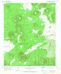
~ White Horse Hills AZ topo map, 1:24000 scale, 7.5 X 7.5 Minute, Historical, 1966, updated 1968
White Horse Hills, Arizona, USGS topographic map dated 1966.
Includes geographic coordinates (latitude and longitude). This topographic map is suitable for hiking, camping, and exploring, or framing it as a wall map.
Printed on-demand using high resolution imagery, on heavy weight and acid free paper, or alternatively on a variety of synthetic materials.
Topos available on paper, Waterproof, Poly, or Tyvek. Usually shipping rolled, unless combined with other folded maps in one order.
- Product Number: USGS-5557214
- Free digital map download (high-resolution, GeoPDF): White Horse Hills, Arizona (file size: 12 MB)
- Map Size: please refer to the dimensions of the GeoPDF map above
- Weight (paper map): ca. 55 grams
- Map Type: POD USGS Topographic Map
- Map Series: HTMC
- Map Verison: Historical
- Cell ID: 48688
- Scan ID: 314050
- Imprint Year: 1968
- Woodland Tint: Yes
- Aerial Photo Year: 1964
- Field Check Year: 1966
- Datum: NAD27
- Map Projection: Polyconic
- Map published by United States Geological Survey
- Map Language: English
- Scanner Resolution: 600 dpi
- Map Cell Name: White Horse Hills
- Grid size: 7.5 X 7.5 Minute
- Date on map: 1966
- Map Scale: 1:24000
- Geographical region: Arizona, United States
Neighboring Maps:
All neighboring USGS topo maps are available for sale online at a variety of scales.
Spatial coverage:
Topo map White Horse Hills, Arizona, covers the geographical area associated the following places:
- Kendrick Park Forest Service Station - Indian Flat - Walker Lake - Indian Tank - Pat Tank - Maverick Butte - Lookout Tank - Road Tank - Pat Tank - Hall Tank - Bonita Tank - Saddle Mountain - Kelly Tank - Tub Number Three - Aubineau Canyon - Pete Number One Tank - Elizabeth Tank - McKinney Tank - Yellow Jacket Tank - Deep Tank - Saddle Trick Tank - Tub Number Two - Potato Tank - Kendrick Tank - Black Tank - Howard Seep Tank - White Horse Hills - Lavin Tank - Reese Tanks - Borrego Trick Tank - Reese Canyon - Pat Spring - Goat Tank - Badger Tank - Tub Number One - White Horse Canyon - Geyler Tank - Howard Seep
- Map Area ID: AREA35.535.375-111.75-111.625
- Northwest corner Lat/Long code: USGSNW35.5-111.75
- Northeast corner Lat/Long code: USGSNE35.5-111.625
- Southwest corner Lat/Long code: USGSSW35.375-111.75
- Southeast corner Lat/Long code: USGSSE35.375-111.625
- Northern map edge Latitude: 35.5
- Southern map edge Latitude: 35.375
- Western map edge Longitude: -111.75
- Eastern map edge Longitude: -111.625


