
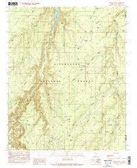
~ Weimer Point AZ topo map, 1:24000 scale, 7.5 X 7.5 Minute, Historical, 1990, updated 1991
Weimer Point, Arizona, USGS topographic map dated 1990.
Includes geographic coordinates (latitude and longitude). This topographic map is suitable for hiking, camping, and exploring, or framing it as a wall map.
Printed on-demand using high resolution imagery, on heavy weight and acid free paper, or alternatively on a variety of synthetic materials.
Topos available on paper, Waterproof, Poly, or Tyvek. Usually shipping rolled, unless combined with other folded maps in one order.
- Product Number: USGS-5557114
- Free digital map download (high-resolution, GeoPDF): Weimer Point, Arizona (file size: 15 MB)
- Map Size: please refer to the dimensions of the GeoPDF map above
- Weight (paper map): ca. 55 grams
- Map Type: POD USGS Topographic Map
- Map Series: HTMC
- Map Verison: Historical
- Cell ID: 47960
- Scan ID: 313999
- Imprint Year: 1991
- Woodland Tint: Yes
- Visual Version Number: 1
- Aerial Photo Year: 1985
- Edit Year: 1990
- Field Check Year: 1987
- Datum: NAD27
- Map Projection: Universal Transverse Mercator
- Provisional map: Yes
- Map published by United States Geological Survey
- Map Language: English
- Scanner Resolution: 600 dpi
- Map Cell Name: Weimer Point
- Grid size: 7.5 X 7.5 Minute
- Date on map: 1990
- Map Scale: 1:24000
- Geographical region: Arizona, United States
Neighboring Maps:
All neighboring USGS topo maps are available for sale online at a variety of scales.
Spatial coverage:
Topo map Weimer Point, Arizona, covers the geographical area associated the following places:
- Smith Canyon - Slim Jim Canyon - Potato Patch Tank - Corner Tank - Horse Trap Canyon - Fat Boy Tank - Houck Draw - Middle Smith Tank - Mogollon Plateau - Little Spring Trick Tank - Lower Smith Tank - Larson Canyon - Tillman Ranch - Fork Tank - Tire Tank - Smith Ridge - Point Tank - Saint Joe Canyon - Potato Patch - Potato Patch Draw - West Fork Circle Bar Draw - Telephone Ridge - Weimer Tank - Breed Spring - Long Tom Canyon - East Fork Chevelon Canyon - Weimer Canyon - Weimer Ridge - Telephone Ridge Trailhead - Houck Tank - Mare Tank - Section Tank - Weimer Point - Little Springs Canyon - Crooked Tank - Larson Spring Tank - West Fork Little Springs Canyon - Slim Jim Ridge - Telephone Tank - Chevelon Ridge Truck Trail - Ridge Tank - Possum Point - Larson Ridge - Section Twenty Tank - Ram Tank - Small Tank - Flat Tank - Long Draw Water Catchment - East Fork Weimer Canyon - East Fork Tank - Dog Tank - Horseshoe Tank - Potato Tank - Saint Joe Ridge - Burn Tank - Pino Real Tank - Pulp Tank - Chevelon Canyon Lake
- Map Area ID: AREA34.534.375-110.875-110.75
- Northwest corner Lat/Long code: USGSNW34.5-110.875
- Northeast corner Lat/Long code: USGSNE34.5-110.75
- Southwest corner Lat/Long code: USGSSW34.375-110.875
- Southeast corner Lat/Long code: USGSSE34.375-110.75
- Northern map edge Latitude: 34.5
- Southern map edge Latitude: 34.375
- Western map edge Longitude: -110.875
- Eastern map edge Longitude: -110.75


