
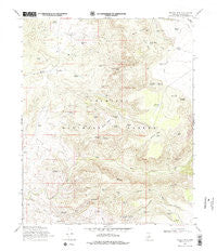
~ Walker Mtn AZ topo map, 1:24000 scale, 7.5 X 7.5 Minute, Historical, 1969, updated 1978
Walker Mtn , Arizona, USGS topographic map dated 1969.
Includes geographic coordinates (latitude and longitude). This topographic map is suitable for hiking, camping, and exploring, or framing it as a wall map.
Printed on-demand using high resolution imagery, on heavy weight and acid free paper, or alternatively on a variety of synthetic materials.
Topos available on paper, Waterproof, Poly, or Tyvek. Usually shipping rolled, unless combined with other folded maps in one order.
- Product Number: USGS-5557048
- Free digital map download (high-resolution, GeoPDF): Walker Mtn , Arizona (file size: 13 MB)
- Map Size: please refer to the dimensions of the GeoPDF map above
- Weight (paper map): ca. 55 grams
- Map Type: POD USGS Topographic Map
- Map Series: HTMC
- Map Verison: Historical
- Cell ID: 47269
- Scan ID: 313965
- Imprint Year: 1978
- Woodland Tint: Yes
- Visual Version Number: 2
- Aerial Photo Year: 1962
- Field Check Year: 1969
- Datum: NAD27
- Map Projection: Polyconic
- Map published by United States Geological Survey
- Map published by United States Forest Service
- Map Language: English
- Scanner Resolution: 600 dpi
- Map Cell Name: Walker Mountain
- Grid size: 7.5 X 7.5 Minute
- Date on map: 1969
- Map Scale: 1:24000
- Geographical region: Arizona, United States
Neighboring Maps:
All neighboring USGS topo maps are available for sale online at a variety of scales.
Spatial coverage:
Topo map Walker Mtn , Arizona, covers the geographical area associated the following places:
- Pesthouse Tank - West Clear Creek Wilderness - Hance Tank - Devils Windpipe - Ninemile Tank - Walker Basin Trail - Last Tank - Cedar Bench - Bald Hill - Elmore Tank Number Two - Quail Trick Tank - Red Tank - Petes Tank - Blodgett Basin Tank - Hollingshead Point Tank - Sawlog Tank Number Two - Vernon Tank - Buckhorn Trail - Cactus Mountain - Thirteenmile Tank - Thirteen Mile Spring - Brockett Tank - Walker Basin Tank - Bald Hill Tank Number Three - Wickiup Tank Number Two - Jawbone Windmill - Bull Pen Ranch - Cedar Mountain - M Diamond Ranch - Blodgett Basin - Diamond M Tank - Hunting Tank - Hilltop Tank - Parsons Tank - F S Tank - Strip Tank - Walker Creek Tank - Black Mountain Canyon - Chalk Point Spring - Section Corner Tank - Bull Pen Campground - Boulder Tank - Walker Rim Tank - Trail Tank - Sawlog Tank Number One - Bald Hill Tank Number Four - Blodgett Tank - Goswick Lake Tank - Cedar Bench Tank Number Two - Cedar Mountain Tank - Walker Basin - Bald Hill Tank Number Five - Tommies Tank - Black Mountain - Cedar Bench Tank Number One - Runner Tank - Bull Tank - Hance Spring - Thirteenmile Rock Butte - Mulcarie Tank - Hollingshead Tank - Black Mountain Tank - Devils Jawbone Tank - Clear Creek Number One Spring - Wickiup Tank Number One - Hollingshead Point - Bald Hill Tank Number Two - Walker Mountain - Clear Creek Number Two Spring
- Map Area ID: AREA34.62534.5-111.75-111.625
- Northwest corner Lat/Long code: USGSNW34.625-111.75
- Northeast corner Lat/Long code: USGSNE34.625-111.625
- Southwest corner Lat/Long code: USGSSW34.5-111.75
- Southeast corner Lat/Long code: USGSSE34.5-111.625
- Northern map edge Latitude: 34.625
- Southern map edge Latitude: 34.5
- Western map edge Longitude: -111.75
- Eastern map edge Longitude: -111.625


