
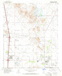
~ Union Hills AZ topo map, 1:24000 scale, 7.5 X 7.5 Minute, Historical, 1964, updated 1966
Union Hills, Arizona, USGS topographic map dated 1964.
Includes geographic coordinates (latitude and longitude). This topographic map is suitable for hiking, camping, and exploring, or framing it as a wall map.
Printed on-demand using high resolution imagery, on heavy weight and acid free paper, or alternatively on a variety of synthetic materials.
Topos available on paper, Waterproof, Poly, or Tyvek. Usually shipping rolled, unless combined with other folded maps in one order.
- Product Number: USGS-5556876
- Free digital map download (high-resolution, GeoPDF): Union Hills, Arizona (file size: 9 MB)
- Map Size: please refer to the dimensions of the GeoPDF map above
- Weight (paper map): ca. 55 grams
- Map Type: POD USGS Topographic Map
- Map Series: HTMC
- Map Verison: Historical
- Cell ID: 71914
- Scan ID: 313880
- Imprint Year: 1966
- Woodland Tint: Yes
- Aerial Photo Year: 1962
- Field Check Year: 1964
- Datum: NAD27
- Map Projection: Polyconic
- Map published by United States Geological Survey
- Map Language: English
- Scanner Resolution: 600 dpi
- Map Cell Name: Union Hills
- Grid size: 7.5 X 7.5 Minute
- Date on map: 1964
- Map Scale: 1:24000
- Geographical region: Arizona, United States
Neighboring Maps:
All neighboring USGS topo maps are available for sale online at a variety of scales.
Spatial coverage:
Topo map Union Hills, Arizona, covers the geographical area associated the following places:
- Phoenix Mobile Home Park - Arbor Manor Mobile Home Park - Sunrise Heights Mobile Home Park - Suncrest Villas East - Steeplechase - The Town Square - Sunset Hills - Paradise Shadows Mobile Home Park - Paradise Valley Mobile Home Park - Moon Valley Canyon - Mountain Shadows Mobile Homes Park - Valley View - Pepper Ridge - Bona Venture Mobile Home Park - Grover Terrace Mobile Home Park - The Phoenix-Scottsdale Mobile Home Park - Central Park Village Mobile Home Park - Palm Lakes Village - Rollin W Mobile Home Ranch - Palm Lakes Village Mobile Home Park - Copper Kettle Trailer Villa - Desert Valley Estates - Central Park Village - El Camino Mobile Home Park - Rose Garden Place III - Aire Libre Mobile Home Park - Shadow Hills Mobile Home Park - Rose Garden Place - Country Ridge - Paradise City - Paradise Valley Mobilhome Park - Parque Vista Estates - Seven Palms Mobile Home Estates - Turf Mobile Manor - Mountain Vista - Bonaventure Mobile Home Community - Val Vista Trailer Park - Orangewood Village Mobilehome Park - Adobe Mountain Trailer Park - Desert Bell Estates II - Desert Sands Mobile Home Park - Eighteen Bells Mobile Home Park - Quail Country Place - Wild Flower - Moon Valley Mobile Home Estates - Marco Polo Mobile Home Park - Whispering Palms Mobile Home Park - Turf Trailer Lodge - Shadow Canyon - Greentrails - Desert Skies Mobile Home Park - Canyon Trails Mobile Home Park - Bell Casas Mobile Home Estates - Villas Plaza - Villa Carmel Mobile Home Park - Liberty Mobile Home Park - Boulder Ridge Mobile Home Park - Adobe - Michigan Palms Mobile Home Park - Paradise North Mobile Home Park - Turtle Creek
- Map Area ID: AREA33.7533.625-112.125-112
- Northwest corner Lat/Long code: USGSNW33.75-112.125
- Northeast corner Lat/Long code: USGSNE33.75-112
- Southwest corner Lat/Long code: USGSSW33.625-112.125
- Southeast corner Lat/Long code: USGSSE33.625-112
- Northern map edge Latitude: 33.75
- Southern map edge Latitude: 33.625
- Western map edge Longitude: -112.125
- Eastern map edge Longitude: -112


