
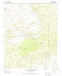
~ Tule Mesa AZ topo map, 1:24000 scale, 7.5 X 7.5 Minute, Historical, 1967, updated 1968
Tule Mesa, Arizona, USGS topographic map dated 1967.
Includes geographic coordinates (latitude and longitude). This topographic map is suitable for hiking, camping, and exploring, or framing it as a wall map.
Printed on-demand using high resolution imagery, on heavy weight and acid free paper, or alternatively on a variety of synthetic materials.
Topos available on paper, Waterproof, Poly, or Tyvek. Usually shipping rolled, unless combined with other folded maps in one order.
- Product Number: USGS-5556814
- Free digital map download (high-resolution, GeoPDF): Tule Mesa, Arizona (file size: 11 MB)
- Map Size: please refer to the dimensions of the GeoPDF map above
- Weight (paper map): ca. 55 grams
- Map Type: POD USGS Topographic Map
- Map Series: HTMC
- Map Verison: Historical
- Cell ID: 45876
- Scan ID: 313848
- Imprint Year: 1968
- Woodland Tint: Yes
- Visual Version Number: 1
- Aerial Photo Year: 1965
- Field Check Year: 1967
- Datum: NAD27
- Map Projection: Polyconic
- Map published by United States Geological Survey
- Map Language: English
- Scanner Resolution: 600 dpi
- Map Cell Name: Tule Mesa
- Grid size: 7.5 X 7.5 Minute
- Date on map: 1967
- Map Scale: 1:24000
- Geographical region: Arizona, United States
Neighboring Maps:
All neighboring USGS topo maps are available for sale online at a variety of scales.
Spatial coverage:
Topo map Tule Mesa, Arizona, covers the geographical area associated the following places:
- Rodeer Spring - Mikes Spring - Quail Tank - Tule Canyon Tank - Lower Tule Water - The Cedars - Lower Bishop Spring - Mikes Cabin - Nelson Trail Number One Hundred Fifty Nine - Hoop-em-up Tank - Willow Spring Tank - Beehouse Spring - Bishop Spring - Yellow Jacket Mesa - IM Peak - Oak Water - Nelson Place Spring - Verde Rim - Road Tank - Little Mesa - Tule Mesa - Lime Spring - Double T Ranch - Dans Spring - Tule Spring - Black Alder Spring - Yellow Jacket Tank Number Two - Brush Water - Cloverleaf - Skeleton Ridge - One Eighth Spring - Buck Basin - Pine Flat Trail - Saddle Tank - Horse Pasture Tank - Brush Spring - Slide Spring - Tule Mountain Tank - Pine Mountain Wilderness - Little Mesa Tanks - Pine Flat - Mockingbird Pass - Pine Mountain - Mount Thomas - Pine Spring - Christmas Tree Tank - Verde Saddle Tank - High Spring - West Water - Buck Basin Tank - Tule Tank - Canyon Water - Duck Spring - Mud Spring - Hidden Spring - Chalk Spring - Rabbit Spring - Lower Cedar Tank Number Two - Willow Spring - Beehouse Canyon - Coldwater Tank Number Two - Verde Rim Trail - Tank Canyon - Thistle Tank - MT Ranch - Cold Water Spring
- Map Area ID: AREA34.37534.25-111.875-111.75
- Northwest corner Lat/Long code: USGSNW34.375-111.875
- Northeast corner Lat/Long code: USGSNE34.375-111.75
- Southwest corner Lat/Long code: USGSSW34.25-111.875
- Southeast corner Lat/Long code: USGSSE34.25-111.75
- Northern map edge Latitude: 34.375
- Southern map edge Latitude: 34.25
- Western map edge Longitude: -111.875
- Eastern map edge Longitude: -111.75


