
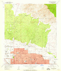
~ Tucson North AZ topo map, 1:24000 scale, 7.5 X 7.5 Minute, Historical, 1957, updated 1959
Tucson North, Arizona, USGS topographic map dated 1957.
Includes geographic coordinates (latitude and longitude). This topographic map is suitable for hiking, camping, and exploring, or framing it as a wall map.
Printed on-demand using high resolution imagery, on heavy weight and acid free paper, or alternatively on a variety of synthetic materials.
Topos available on paper, Waterproof, Poly, or Tyvek. Usually shipping rolled, unless combined with other folded maps in one order.
- Product Number: USGS-5556762
- Free digital map download (high-resolution, GeoPDF): Tucson North, Arizona (file size: 14 MB)
- Map Size: please refer to the dimensions of the GeoPDF map above
- Weight (paper map): ca. 55 grams
- Map Type: POD USGS Topographic Map
- Map Series: HTMC
- Map Verison: Historical
- Cell ID: 45850
- Scan ID: 313828
- Imprint Year: 1959
- Woodland Tint: Yes
- Aerial Photo Year: 1954
- Survey Year: 1957
- Datum: NAD27
- Map Projection: Polyconic
- Map published by United States Geological Survey
- Map Language: English
- Scanner Resolution: 600 dpi
- Map Cell Name: Tucson North
- Grid size: 7.5 X 7.5 Minute
- Date on map: 1957
- Map Scale: 1:24000
- Geographical region: Arizona, United States
Neighboring Maps:
All neighboring USGS topo maps are available for sale online at a variety of scales.
Spatial coverage:
Topo map Tucson North, Arizona, covers the geographical area associated the following places:
- Paradise Village Mobile Estates - Pueblo Springs Mobile Home Estates - Bermuda Gardens Trailer Park - Amphitheater - Swan Lake Estates Mobile Home Park - Casas Adobes - Palm Harbour Estates Mobile Home Park - Vista Del Norte Mobile Estates - Oracle Foothills Estates - El Frontier Mobile Home Park - BeLaire Mobile Home Park - Catalina Foothills - Terra Vista Estates Mobile Home Park - Lamplighter Mobile Home Park - Catalina Vista Mobile Home Community - Rancho Los Amigos Mobile Home Park - Five Star Mobile Home Park - Carousel Ranch Mobile Home Park - Aloha Mobile Home Park - Columbia Mobile Home Park - Fairview Manor Mobile Home Park - Crescent Manor Mobile Home Community - Desert Shores Mobile Home Park - Foothills Mobile Home Park - Prince Mobile Home Park - Santa Catalina Mobile Home Park - Valley View - Friendly Village Estates Mobile Home Park - Parkway Vista Mobile Home Park - El Molino Mobile Home Park - Fairhaven Mobile Home Park - Leisure Village Mobile Home Park - Cielo Vista Mobile Home Park - Campbell Estates Mobile Home Park - Cammie's Foothills Vista Mobile Home Park - Desert Palms Mobile Home Park - Sleepy Hollow Mobile Home Estates - Shar I Don Trailer Park - Skyline Bel Aire Estates - Friendly Village of the Catalinas Mobile Home Park
- Map Area ID: AREA32.37532.25-111-110.875
- Northwest corner Lat/Long code: USGSNW32.375-111
- Northeast corner Lat/Long code: USGSNE32.375-110.875
- Southwest corner Lat/Long code: USGSSW32.25-111
- Southeast corner Lat/Long code: USGSSE32.25-110.875
- Northern map edge Latitude: 32.375
- Southern map edge Latitude: 32.25
- Western map edge Longitude: -111
- Eastern map edge Longitude: -110.875


