
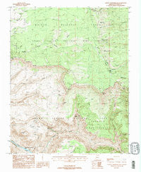
~ Tapeats Amphitheater AZ topo map, 1:24000 scale, 7.5 X 7.5 Minute, Historical, 1988, updated 1988
Tapeats Amphitheater, Arizona, USGS topographic map dated 1988.
Includes geographic coordinates (latitude and longitude). This topographic map is suitable for hiking, camping, and exploring, or framing it as a wall map.
Printed on-demand using high resolution imagery, on heavy weight and acid free paper, or alternatively on a variety of synthetic materials.
Topos available on paper, Waterproof, Poly, or Tyvek. Usually shipping rolled, unless combined with other folded maps in one order.
- Product Number: USGS-5556460
- Free digital map download (high-resolution, GeoPDF): Tapeats Amphitheater, Arizona (file size: 15 MB)
- Map Size: please refer to the dimensions of the GeoPDF map above
- Weight (paper map): ca. 55 grams
- Map Type: POD USGS Topographic Map
- Map Series: HTMC
- Map Verison: Historical
- Cell ID: 44297
- Scan ID: 313663
- Imprint Year: 1988
- Woodland Tint: Yes
- Aerial Photo Year: 1982
- Edit Year: 1988
- Field Check Year: 1985
- Datum: NAD27
- Map Projection: Transverse Mercator
- Map published by United States Geological Survey
- Map Language: English
- Scanner Resolution: 600 dpi
- Map Cell Name: Tapeats Amphitheater
- Grid size: 7.5 X 7.5 Minute
- Date on map: 1988
- Map Scale: 1:24000
- Geographical region: Arizona, United States
Neighboring Maps:
All neighboring USGS topo maps are available for sale online at a variety of scales.
Spatial coverage:
Topo map Tapeats Amphitheater, Arizona, covers the geographical area associated the following places:
- South Big Saddle Point - Big Saddle Tank - Monument Point - Big Saddle - Indian Hollow Campground - Kwagunt Trick Tank - Crazy Jug Spring - Tapeats Amphitheater - Parissawampitts Canyon - Indian Hollow Wildlife Apron - Burnt Corral Point - Bill Hall Trail - Tapeats Terrace - Indian Hollow Trick Tank - Stina Canyon - Tapeats Spring - Fence Point - Thunder Spring - Bonita Creek - Hundred and Thirtyfive Mile Rapids - Crazy Jug Canyon - Parissawampitts Point - Sowats Trick Tank - Thunder River - Crazy Jug Point - Big Saddle Point - Bridgers Knoll - Burnt Corral Canyon - Rice Hollow - Indian Hollow-Thunder Springs Trail Twenty-three - Timp Canyon - Cogswell Butte - South Burnt Corral Point - Big Saddle Camp - Saddle Canyon - Rice Hollow Trick Tank - Surprise Valley - North Big Saddle Point
- Map Area ID: AREA36.536.375-112.5-112.375
- Northwest corner Lat/Long code: USGSNW36.5-112.5
- Northeast corner Lat/Long code: USGSNE36.5-112.375
- Southwest corner Lat/Long code: USGSSW36.375-112.5
- Southeast corner Lat/Long code: USGSSE36.375-112.375
- Northern map edge Latitude: 36.5
- Southern map edge Latitude: 36.375
- Western map edge Longitude: -112.5
- Eastern map edge Longitude: -112.375


