
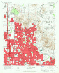
~ Sunnyslope AZ topo map, 1:24000 scale, 7.5 X 7.5 Minute, Historical, 1965, updated 1967
Sunnyslope, Arizona, USGS topographic map dated 1965.
Includes geographic coordinates (latitude and longitude). This topographic map is suitable for hiking, camping, and exploring, or framing it as a wall map.
Printed on-demand using high resolution imagery, on heavy weight and acid free paper, or alternatively on a variety of synthetic materials.
Topos available on paper, Waterproof, Poly, or Tyvek. Usually shipping rolled, unless combined with other folded maps in one order.
- Product Number: USGS-5556312
- Free digital map download (high-resolution, GeoPDF): Sunnyslope, Arizona (file size: 13 MB)
- Map Size: please refer to the dimensions of the GeoPDF map above
- Weight (paper map): ca. 55 grams
- Map Type: POD USGS Topographic Map
- Map Series: HTMC
- Map Verison: Historical
- Cell ID: 71762
- Scan ID: 313586
- Imprint Year: 1967
- Woodland Tint: Yes
- Aerial Photo Year: 1962
- Field Check Year: 1965
- Datum: NAD27
- Map Projection: Polyconic
- Map published by United States Geological Survey
- Map Language: English
- Scanner Resolution: 600 dpi
- Map Cell Name: Sunnyslope
- Grid size: 7.5 X 7.5 Minute
- Date on map: 1965
- Map Scale: 1:24000
- Geographical region: Arizona, United States
Neighboring Maps:
All neighboring USGS topo maps are available for sale online at a variety of scales.
Spatial coverage:
Topo map Sunnyslope, Arizona, covers the geographical area associated the following places:
- Shadow Mountain - Cactus - Estate Monterra - Wabash Trailer Court - Sun n Sand Mobile Home Park - Peri-Winkle Mobile Home Park - Stony Mountain Villas - Mayflower Terrace - Royal Palm Travel Trailer and Mobile Home Park - Cactus Gardens Mobile Home Park - Colony Biltmore IV - Heritage Highlands - Canyon Village - New Home Mobile Park - Silver Bell Trailer Park (historical) - Thunderbird Valley Number Two - Covered Wagon Mobile Home Park - The Preserve - Citrus Grove Trailer Park - Ridgegate - Biltmore Greens III - Welcome Home Mobile Park - Biltmore Gates - Lake Biltmore Estates - Singing Spur Mobile Park - Sunny Slope Mobile Home Park - Glen Canyon Trailer Park - Lookout Mountain - Skyline Heights - Villa Novena - Palmas Royale - Rancho San Carlos - Mountain View Trailer Court - Chris-Town Travel Trailer and Mobile Home Park - Town and Country Mobile Home Park - Oregon Trail Mobile Home Park - Biltmore Villas - Highland Terrace Mobile Home Park - Village on the Lakes - Paradise Valley Oasis - The Pointe - Colony South - Claremont Place - Sunset North - Taliverde - Hi View Mobile Home Park - Sunnyslope - Holiday Spa Mobile Home Park
- Map Area ID: AREA33.62533.5-112.125-112
- Northwest corner Lat/Long code: USGSNW33.625-112.125
- Northeast corner Lat/Long code: USGSNE33.625-112
- Southwest corner Lat/Long code: USGSSW33.5-112.125
- Southeast corner Lat/Long code: USGSSE33.5-112
- Northern map edge Latitude: 33.625
- Southern map edge Latitude: 33.5
- Western map edge Longitude: -112.125
- Eastern map edge Longitude: -112


