
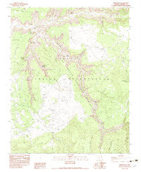
~ Spider Rock AZ topo map, 1:24000 scale, 7.5 X 7.5 Minute, Historical, 1983, updated 1983
Spider Rock, Arizona, USGS topographic map dated 1983.
Includes geographic coordinates (latitude and longitude). This topographic map is suitable for hiking, camping, and exploring, or framing it as a wall map.
Printed on-demand using high resolution imagery, on heavy weight and acid free paper, or alternatively on a variety of synthetic materials.
Topos available on paper, Waterproof, Poly, or Tyvek. Usually shipping rolled, unless combined with other folded maps in one order.
- Product Number: USGS-5556084
- Free digital map download (high-resolution, GeoPDF): Spider Rock, Arizona (file size: 12 MB)
- Map Size: please refer to the dimensions of the GeoPDF map above
- Weight (paper map): ca. 55 grams
- Map Type: POD USGS Topographic Map
- Map Series: HTMC
- Map Verison: Historical
- Cell ID: 42500
- Scan ID: 313484
- Imprint Year: 1983
- Woodland Tint: Yes
- Aerial Photo Year: 1976
- Edit Year: 1983
- Field Check Year: 1977
- Datum: NAD27
- Map Projection: Transverse Mercator
- Provisional map: Yes
- Map published by United States Geological Survey
- Map Language: English
- Scanner Resolution: 600 dpi
- Map Cell Name: Spider Rock
- Grid size: 7.5 X 7.5 Minute
- Date on map: 1983
- Map Scale: 1:24000
- Geographical region: Arizona, United States
Neighboring Maps:
All neighboring USGS topo maps are available for sale online at a variety of scales.
Spatial coverage:
Topo map Spider Rock, Arizona, covers the geographical area associated the following places:
- Spider Rock - Bat Canyon - Oak Spring - Small Twin Canyon - Mule Canyon - Monument Canyon Wash - Hot Rock Windmill - Elephant Grass Spring - Two Hole Ruin - Face Rock - Bat Rock - Horse Track Canyon - Cave Ruin - Monument Canyon - Glofer Spring - Spider Rock Overlook - Canyon de Chelly National Monument
- Map Area ID: AREA36.12536-109.375-109.25
- Northwest corner Lat/Long code: USGSNW36.125-109.375
- Northeast corner Lat/Long code: USGSNE36.125-109.25
- Southwest corner Lat/Long code: USGSSW36-109.375
- Southeast corner Lat/Long code: USGSSE36-109.25
- Northern map edge Latitude: 36.125
- Southern map edge Latitude: 36
- Western map edge Longitude: -109.375
- Eastern map edge Longitude: -109.25


