
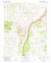
~ Russell Spring AZ topo map, 1:24000 scale, 7.5 X 7.5 Minute, Historical, 1979, updated 1982
Russell Spring, Arizona, USGS topographic map dated 1979.
Includes geographic coordinates (latitude and longitude). This topographic map is suitable for hiking, camping, and exploring, or framing it as a wall map.
Printed on-demand using high resolution imagery, on heavy weight and acid free paper, or alternatively on a variety of synthetic materials.
Topos available on paper, Waterproof, Poly, or Tyvek. Usually shipping rolled, unless combined with other folded maps in one order.
- Product Number: USGS-5555484
- Free digital map download (high-resolution, GeoPDF): Russell Spring, Arizona (file size: 12 MB)
- Map Size: please refer to the dimensions of the GeoPDF map above
- Weight (paper map): ca. 55 grams
- Map Type: POD USGS Topographic Map
- Map Series: HTMC
- Map Verison: Historical
- Cell ID: 38998
- Scan ID: 313162
- Imprint Year: 1982
- Woodland Tint: Yes
- Aerial Photo Year: 1974
- Edit Year: 1979
- Field Check Year: 1975
- Datum: NAD27
- Map Projection: Transverse Mercator
- Map published by United States Geological Survey
- Map Language: English
- Scanner Resolution: 600 dpi
- Map Cell Name: Russell Spring
- Grid size: 7.5 X 7.5 Minute
- Date on map: 1979
- Map Scale: 1:24000
- Geographical region: Arizona, United States
Neighboring Maps:
All neighboring USGS topo maps are available for sale online at a variety of scales.
Spatial coverage:
Topo map Russell Spring, Arizona, covers the geographical area associated the following places:
- Upper Hurricane Valley - Chic Pond - Sheep Pockets Trough - Guaranteed Pond - Gyp Reservoir - Woody Pond - D-Six Pond - Childers Well - Keller Pond - Russell Spring - Diamond Butte - Salt Pond - Sugar Pond - Carroll Catchment Tank - Sheep Pockets Reservoir - Ferg Pond - Big D Reservoir - Sunshine Tank - Hidden Tank - Iverson Detention Dam - Twin Butte - McCullan Reservoir - J W Spendlove Reservoir
- Map Area ID: AREA36.62536.5-113.375-113.25
- Northwest corner Lat/Long code: USGSNW36.625-113.375
- Northeast corner Lat/Long code: USGSNE36.625-113.25
- Southwest corner Lat/Long code: USGSSW36.5-113.375
- Southeast corner Lat/Long code: USGSSE36.5-113.25
- Northern map edge Latitude: 36.625
- Southern map edge Latitude: 36.5
- Western map edge Longitude: -113.375
- Eastern map edge Longitude: -113.25


