
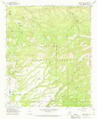
~ Robinson Mesa AZ topo map, 1:24000 scale, 7.5 X 7.5 Minute, Historical, 1967, updated 1970
Robinson Mesa, Arizona, USGS topographic map dated 1967.
Includes geographic coordinates (latitude and longitude). This topographic map is suitable for hiking, camping, and exploring, or framing it as a wall map.
Printed on-demand using high resolution imagery, on heavy weight and acid free paper, or alternatively on a variety of synthetic materials.
Topos available on paper, Waterproof, Poly, or Tyvek. Usually shipping rolled, unless combined with other folded maps in one order.
- Product Number: USGS-5555382
- Free digital map download (high-resolution, GeoPDF): Robinson Mesa, Arizona (file size: 11 MB)
- Map Size: please refer to the dimensions of the GeoPDF map above
- Weight (paper map): ca. 55 grams
- Map Type: POD USGS Topographic Map
- Map Series: HTMC
- Map Verison: Historical
- Cell ID: 38162
- Scan ID: 313108
- Imprint Year: 1970
- Woodland Tint: Yes
- Aerial Photo Year: 1966
- Field Check Year: 1967
- Datum: NAD27
- Map Projection: Polyconic
- Map published by United States Geological Survey
- Map Language: English
- Scanner Resolution: 600 dpi
- Map Cell Name: Robinson Mesa
- Grid size: 7.5 X 7.5 Minute
- Date on map: 1967
- Map Scale: 1:24000
- Geographical region: Arizona, United States
Neighboring Maps:
All neighboring USGS topo maps are available for sale online at a variety of scales.
Spatial coverage:
Topo map Robinson Mesa, Arizona, covers the geographical area associated the following places:
- Mud Springs Trail Forty-nine - Hogtrail Canyon - Hot Air Tank - Road Tank - Hogtrail Corral - Big Pasture Tank - Coyote Tank - West Fork Tank - Black Mountain Tank - Adbar Trail Fourteen - Sheep Saddle - Mud Springs Corral - Circle Canyon Stock Tank - G J Filleman Ranch - Robinson Mesa Twenty-seven Trail - Mud Springs Canyon Tank - Sandy Tank - Blackwater Pit Tank - Tercer Springs Number Three - Trail Tank - Hot Air Trail Fifteen - Bailey Place Corral - Robinson Mesa - Tercer Springs Number One - Honeymoon Campground - Mud Springs Corral - Mud Springs - Bear Cub Spring - Seven Cross A Ranch - Blue Range - Bear Spring Number One - West Fork Hot Air Canyon - Mud Springs Tank Number Two - Middle Prong Creek - Caborne Tank - Mud Springs Tank Number One - Glover Ridge - Robinson Mesa Tank - Tercer Springs Number Two - Goodwin Tank - Crabtree Creek - Juniper Spring - Robinson Canyon - East Eagle Creek - Sawmill Cabin - P Tank - East Eagle Tank - Hot Air Canyon - Pine Canyon - Robinson Spring - Four Drag Ranch - Robinson Mesa Corral - Bear Spring - Ranch Corral - Wet Prong Creek - East Eagle Trail Thirty-Three - Bear Canyon Trail - Glover Tank - Dry Prong Creek
- Map Area ID: AREA33.533.375-109.5-109.375
- Northwest corner Lat/Long code: USGSNW33.5-109.5
- Northeast corner Lat/Long code: USGSNE33.5-109.375
- Southwest corner Lat/Long code: USGSSW33.375-109.5
- Southeast corner Lat/Long code: USGSSE33.375-109.375
- Northern map edge Latitude: 33.5
- Southern map edge Latitude: 33.375
- Western map edge Longitude: -109.5
- Eastern map edge Longitude: -109.375


