
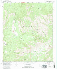
~ Pipestem Mountain AZ topo map, 1:24000 scale, 7.5 X 7.5 Minute, Historical, 1967, updated 1985
Pipestem Mountain, Arizona, USGS topographic map dated 1967.
Includes geographic coordinates (latitude and longitude). This topographic map is suitable for hiking, camping, and exploring, or framing it as a wall map.
Printed on-demand using high resolution imagery, on heavy weight and acid free paper, or alternatively on a variety of synthetic materials.
Topos available on paper, Waterproof, Poly, or Tyvek. Usually shipping rolled, unless combined with other folded maps in one order.
- Product Number: USGS-5555026
- Free digital map download (high-resolution, GeoPDF): Pipestem Mountain, Arizona (file size: 13 MB)
- Map Size: please refer to the dimensions of the GeoPDF map above
- Weight (paper map): ca. 55 grams
- Map Type: POD USGS Topographic Map
- Map Series: HTMC
- Map Verison: Historical
- Cell ID: 35427
- Scan ID: 312926
- Imprint Year: 1985
- Woodland Tint: Yes
- Aerial Photo Year: 1966
- Field Check Year: 1967
- Datum: NAD27
- Map Projection: Polyconic
- Map published by United States Geological Survey
- Map Language: English
- Scanner Resolution: 600 dpi
- Map Cell Name: Pipestem Mountain
- Grid size: 7.5 X 7.5 Minute
- Date on map: 1967
- Map Scale: 1:24000
- Geographical region: Arizona, United States
Neighboring Maps:
All neighboring USGS topo maps are available for sale online at a variety of scales.
Spatial coverage:
Topo map Pipestem Mountain, Arizona, covers the geographical area associated the following places:
- Mountain Corral - Trail Spring - Turkey Tank - Mountain Lion Spring - Trail Cabin Forest Service Facility - Frog Spring - T Links Ranch - Pipestem Mountain - Joe Tank - CCC Tank - Trail Cabin Tank - Middle Tank - Salt Box Tank - Clear Creek Cabin - Filleman Tank - Pigeon Spring Number One - Clear Creek Corral - H L Canyon - Turkey Creek Corral - Drunk Spring - Pipestem Mountain Tank - Trail Tank - New Mesa Tank - Pipestem Spring - Pine Flat Cortral - Podsol Springs - Bear Paw Spring - WJ Tank - Double Tank - Sulfur Spring - Tinny Cabin Corral - Sleep Spring - Slaughter House Springs - Rock Spring - Chichi Tank - Stock Tank Number Three - N O Bar Mesa Tank Number Two - Lower Pipestem Corral - Line Spring - Pipestem Creek - Shipping Tank - Stock Number Two Tank - Clifton Ranger District - Tinny Tank - Hiway Tank - Four Bar Mesa Corral - Dry Tank - N O Bar Mesa - Washout Spring - Chain Springs Number One - Low Canyon Tank - Dry Spring - Chain Springs Number Four - Turn Springs - Bar Springs - Pigeon Spring Number Two - Broken Spring - Shipping Corral - Four Bar Mesa Tanks - Tube Tank - Four Bar Mesa - Lower Juan Miller Campground - Flat Spring - Mesa Tank - Pipestem Canyon - Unknown Spring - Pine Flat Corral - Turkey Creek - Cow Canyon - Four Bar Mesa Cabin - Pine Log Tank - Chain Springs Number Three - Glass Spring - Flow Spring - Picket Corral - Clifton Division - No Name Spring - Slow Spring - Corner Tank - Wet Spring - Upper Juan Miller Campground - Fence Tank - Rocky Tank - Burns Tank - Camp Stool Spring - Four Bar Tank - Lower Tube Spring - Juan Miller Corral - Upper Juan Miller Picnic Area - Ridge Tank - Lower Juan Miller Springs - Running Spring - Sob Spring - Chain Springs Number Two - Little Tank - Lower Juan Miller Springs Number One
- Map Area ID: AREA33.37533.25-109.375-109.25
- Northwest corner Lat/Long code: USGSNW33.375-109.375
- Northeast corner Lat/Long code: USGSNE33.375-109.25
- Southwest corner Lat/Long code: USGSSW33.25-109.375
- Southeast corner Lat/Long code: USGSSE33.25-109.25
- Northern map edge Latitude: 33.375
- Southern map edge Latitude: 33.25
- Western map edge Longitude: -109.375
- Eastern map edge Longitude: -109.25


