
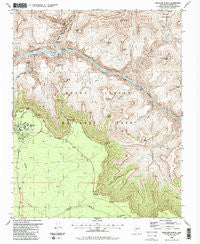
~ Phantom Ranch AZ topo map, 1:24000 scale, 7.5 X 7.5 Minute, Historical, 1988, updated 1988
Phantom Ranch, Arizona, USGS topographic map dated 1988.
Includes geographic coordinates (latitude and longitude). This topographic map is suitable for hiking, camping, and exploring, or framing it as a wall map.
Printed on-demand using high resolution imagery, on heavy weight and acid free paper, or alternatively on a variety of synthetic materials.
Topos available on paper, Waterproof, Poly, or Tyvek. Usually shipping rolled, unless combined with other folded maps in one order.
- Product Number: USGS-5554868
- Free digital map download (high-resolution, GeoPDF): Phantom Ranch, Arizona (file size: 17 MB)
- Map Size: please refer to the dimensions of the GeoPDF map above
- Weight (paper map): ca. 55 grams
- Map Type: POD USGS Topographic Map
- Map Series: HTMC
- Map Verison: Historical
- Cell ID: 34932
- Scan ID: 312845
- Imprint Year: 1988
- Woodland Tint: Yes
- Visual Version Number: 2
- Aerial Photo Year: 1982
- Edit Year: 1988
- Field Check Year: 1985
- Datum: NAD27
- Map Projection: Transverse Mercator
- Map published by United States Geological Survey
- Map Language: English
- Scanner Resolution: 600 dpi
- Map Cell Name: Phantom Ranch
- Grid size: 7.5 X 7.5 Minute
- Date on map: 1988
- Map Scale: 1:24000
- Geographical region: Arizona, United States
Neighboring Maps:
All neighboring USGS topo maps are available for sale online at a variety of scales.
Spatial coverage:
Topo map Phantom Ranch, Arizona, covers the geographical area associated the following places:
- Phantom Ranger Station - Zoroaster Temple - Holloway Tank - O'Neill Butte - Plateau Point - Pipe Spring - Natural Arch - Phantom Canyon - Pipe Creek - Cremation Creek - Cheops Pyramid - River Trail - The Box - Grand Canyon National Park Visitor Center - South Entrance Station - Eightyfive Mile Rapids - Zoroaster Canyon - The Howlands Butte - Phantom Creek - Kaibab Suspension Bridge - Clear Creek - Silver Bridge - Berry Butte - Newton Butte - South Kaibab Trail - Indian Garden - Lyell Butte - Sumner Butte - Shoshone Point - Bradley Point - Bright Angel Creek - Sumner Point - Grapevine Rapids - Lonetree Canyon - Bright Angel Canyon - Hawkins Butte - Demaray Point - Clear Creek Trail - Garden Creek - Boulder Creek - Visitor Center Campground - Cedar Ridge - Grandeur Point - Grapevine Creek - Suspension Bridge Campground - Mather Point - Phantom Ranch - Yavapai Point - Ottoman Amphitheater - Burro Spring - Eightythree Mile Rapids - Yaki Point - Pattie Butte - The Tipoff
- Map Area ID: AREA36.12536-112.125-112
- Northwest corner Lat/Long code: USGSNW36.125-112.125
- Northeast corner Lat/Long code: USGSNE36.125-112
- Southwest corner Lat/Long code: USGSSW36-112.125
- Southeast corner Lat/Long code: USGSSE36-112
- Northern map edge Latitude: 36.125
- Southern map edge Latitude: 36
- Western map edge Longitude: -112.125
- Eastern map edge Longitude: -112


