
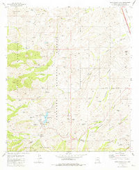
~ Pena Blanca Lake AZ topo map, 1:24000 scale, 7.5 X 7.5 Minute, Historical, 1981, updated 1981
Pena Blanca Lake, Arizona, USGS topographic map dated 1981.
Includes geographic coordinates (latitude and longitude). This topographic map is suitable for hiking, camping, and exploring, or framing it as a wall map.
Printed on-demand using high resolution imagery, on heavy weight and acid free paper, or alternatively on a variety of synthetic materials.
Topos available on paper, Waterproof, Poly, or Tyvek. Usually shipping rolled, unless combined with other folded maps in one order.
- Product Number: USGS-5554824
- Free digital map download (high-resolution, GeoPDF): Pena Blanca Lake, Arizona (file size: 12 MB)
- Map Size: please refer to the dimensions of the GeoPDF map above
- Weight (paper map): ca. 55 grams
- Map Type: POD USGS Topographic Map
- Map Series: HTMC
- Map Verison: Historical
- Cell ID: 34684
- Scan ID: 312824
- Imprint Year: 1981
- Woodland Tint: Yes
- Aerial Photo Year: 1975
- Edit Year: 1981
- Field Check Year: 1976
- Datum: NAD27
- Map Projection: Transverse Mercator
- Map published by United States Geological Survey
- Map Language: English
- Scanner Resolution: 600 dpi
- Map Cell Name: Pena Blanca Lake
- Grid size: 7.5 X 7.5 Minute
- Date on map: 1981
- Map Scale: 1:24000
- Geographical region: Arizona, United States
Neighboring Maps:
All neighboring USGS topo maps are available for sale online at a variety of scales.
Spatial coverage:
Topo map Pena Blanca Lake, Arizona, covers the geographical area associated the following places:
- Peña Blanca Dam - Nogales Division - Alamo Canyon - Toruno Tank - Rock Water Spring - Rock Tank - Peck Well - Noonville (historical) - Wisdom Tank - Turuno Canyon - Peña Blanca Lake - Upper Pesqueira Tank - Lower Alamo Tank - Caralampi Tank - Morning Mine - Peña Blanca Canyon - Boulder Tank - Walker Canyon - Agua Fria Canyon - Rio Rico Southwest Census Designated Place (historical) - Split Tank - White Oak Tank - CCC Tank - Cumming Ranch - Bellota Spring - Basin Tank - White Rock Campground - Ramanote Wells - Thumb Rock Picnic Area - Buckshot Tank - Castle Tank - Walker Tank - Toruno Canyon - Cruz Canyon Tank - Puerto de la Cruz - Lower Bellota Tank - Middle Alamo Tank - Dutchman Tank - Calabasas Picnic Area - Waterfall Spring - Twin Tank - Lion Mountain - Bellotosa Tank - Caralampi Tank - Kane Ranch - Bobby Tank - Rio Rico Airstrip (historical) - Wolf Canyon Tank - Ramanote Canyon - Lowell Ranch - Saint Patrick Mine - Peña Blanca Spring - Cottonwood Spring - Peña Blanca Trail Number Forty-one - H Six Tank - Basin Tank - Rock Water Spring - Bellota Tank - Big Steve Mine - Fresno Canyon - H Six Well - Mesa Side Tank - Lost Tank - Bellota Canyon - Red Rock Picnic Area - Wise Mesa - Lost Dog Canyon - Dove Tank - Castle Rock
- Map Area ID: AREA31.531.375-111.125-111
- Northwest corner Lat/Long code: USGSNW31.5-111.125
- Northeast corner Lat/Long code: USGSNE31.5-111
- Southwest corner Lat/Long code: USGSSW31.375-111.125
- Southeast corner Lat/Long code: USGSSE31.375-111
- Northern map edge Latitude: 31.5
- Southern map edge Latitude: 31.375
- Western map edge Longitude: -111.125
- Eastern map edge Longitude: -111


