
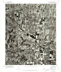
~ Paradise Valley AZ topo map, 1:24000 scale, 7.5 X 7.5 Minute, Historical, 1971, updated 1972
Paradise Valley, Arizona, USGS topographic map dated 1971.
Includes geographic coordinates (latitude and longitude). This topographic map is suitable for hiking, camping, and exploring, or framing it as a wall map.
Printed on-demand using high resolution imagery, on heavy weight and acid free paper, or alternatively on a variety of synthetic materials.
Topos available on paper, Waterproof, Poly, or Tyvek. Usually shipping rolled, unless combined with other folded maps in one order.
- Product Number: USGS-5554712
- Free digital map download (high-resolution, GeoPDF): Paradise Valley, Arizona (file size: 17 MB)
- Map Size: please refer to the dimensions of the GeoPDF map above
- Weight (paper map): ca. 55 grams
- Map Type: POD USGS Topographic Map
- Map Series: HTMC
- Map Verison: Historical
- Cell ID: 34170
- Scan ID: 312768
- Imprint Year: 1972
- Aerial Photo Year: 1971
- Datum: NAD27
- Map Projection: Transverse Mercator
- Orthophoto: Quad
- Map published by United States Geological Survey
- Keywords: Nonstandard Press Run
- Map Language: English
- Scanner Resolution: 600 dpi
- Map Cell Name: Paradise Valley
- Grid size: 7.5 X 7.5 Minute
- Date on map: 1971
- Map Scale: 1:24000
- Geographical region: Arizona, United States
Neighboring Maps:
All neighboring USGS topo maps are available for sale online at a variety of scales.
Spatial coverage:
Topo map Paradise Valley, Arizona, covers the geographical area associated the following places:
- Country Horizons - Woodleaf - Village Fairways - Cinco Soles - Paradise Valley - Hyde Park - Kensington - Santo Tomas - The Covey - Clearview Hills - Heritage Terrace - McCormick Ranch - Estados de La Mancha II - Cobblestone Square - Woodleaf II - Scottsdale - Sweetwater Garden - Links Point - Greenbrier East - Windemere - Sweetwater Ranch - Vista del Cerro - Santiago - Orangetree Estates - Buenavante - Las Villas - Desert Wind II - El Paseo - Shadow Ridge II - Gainey Ranch - Firebrand Ranch - Doubletree Canyon - Camelback Estates IV - Paradise Village North II - Sun Valley Mobile Home Park
- Map Area ID: AREA33.62533.5-112-111.875
- Northwest corner Lat/Long code: USGSNW33.625-112
- Northeast corner Lat/Long code: USGSNE33.625-111.875
- Southwest corner Lat/Long code: USGSSW33.5-112
- Southeast corner Lat/Long code: USGSSE33.5-111.875
- Northern map edge Latitude: 33.625
- Southern map edge Latitude: 33.5
- Western map edge Longitude: -112
- Eastern map edge Longitude: -111.875


