
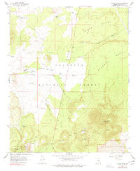
~ O Leary Peak AZ topo map, 1:24000 scale, 7.5 X 7.5 Minute, Historical, 1966, updated 1977
O Leary Peak, Arizona, USGS topographic map dated 1966.
Includes geographic coordinates (latitude and longitude). This topographic map is suitable for hiking, camping, and exploring, or framing it as a wall map.
Printed on-demand using high resolution imagery, on heavy weight and acid free paper, or alternatively on a variety of synthetic materials.
Topos available on paper, Waterproof, Poly, or Tyvek. Usually shipping rolled, unless combined with other folded maps in one order.
- Product Number: USGS-5554576
- Free digital map download (high-resolution, GeoPDF): O Leary Peak, Arizona (file size: 10 MB)
- Map Size: please refer to the dimensions of the GeoPDF map above
- Weight (paper map): ca. 55 grams
- Map Type: POD USGS Topographic Map
- Map Series: HTMC
- Map Verison: Historical
- Cell ID: 32696
- Scan ID: 312700
- Imprint Year: 1977
- Woodland Tint: Yes
- Photo Inspection Year: 1974
- Aerial Photo Year: 1974
- Field Check Year: 1966
- Datum: NAD27
- Map Projection: Polyconic
- Map published by United States Geological Survey
- Map Language: English
- Scanner Resolution: 600 dpi
- Map Cell Name: O'Leary Peak
- Grid size: 7.5 X 7.5 Minute
- Date on map: 1966
- Map Scale: 1:24000
- Geographical region: Arizona, United States
Neighboring Maps:
All neighboring USGS topo maps are available for sale online at a variety of scales.
Spatial coverage:
Topo map O Leary Peak, Arizona, covers the geographical area associated the following places:
- Tank Four - Medicine Valley - Tank Seven - Stagg Tank - Espil Ranch - Chicos Tank - O'Leary Peak Lookout Tower - Carr Tank - Old Grand Canyon Tank - O'Leary Peak - Deadman Flat - Deadman Tank - Sawmill Tank - Lucky Tank - Pete Tank - Dove Tank - French Tank - Lost Tank - Osborne Tank - Cedar Ridge - Bear Jaw Canyon - Sinagua Valley - Boswell Tank - Pierre Tank - Hostetter Tank - Deadman Mesa - Alto Spring - Chavez Tank - Robinson Crater - Sacred Mountain Trading Post - Robinson Mountain - Darton Dome - Tank Six - Tank Eight - Bedground Ridge
- Map Area ID: AREA35.535.375-111.625-111.5
- Northwest corner Lat/Long code: USGSNW35.5-111.625
- Northeast corner Lat/Long code: USGSNE35.5-111.5
- Southwest corner Lat/Long code: USGSSW35.375-111.625
- Southeast corner Lat/Long code: USGSSE35.375-111.5
- Northern map edge Latitude: 35.5
- Southern map edge Latitude: 35.375
- Western map edge Longitude: -111.625
- Eastern map edge Longitude: -111.5


