
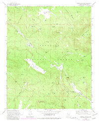
~ Mormon Mountain AZ topo map, 1:24000 scale, 7.5 X 7.5 Minute, Historical, 1965, updated 1981
Mormon Mountain, Arizona, USGS topographic map dated 1965.
Includes geographic coordinates (latitude and longitude). This topographic map is suitable for hiking, camping, and exploring, or framing it as a wall map.
Printed on-demand using high resolution imagery, on heavy weight and acid free paper, or alternatively on a variety of synthetic materials.
Topos available on paper, Waterproof, Poly, or Tyvek. Usually shipping rolled, unless combined with other folded maps in one order.
- Product Number: USGS-5554124
- Free digital map download (high-resolution, GeoPDF): Mormon Mountain, Arizona (file size: 10 MB)
- Map Size: please refer to the dimensions of the GeoPDF map above
- Weight (paper map): ca. 55 grams
- Map Type: POD USGS Topographic Map
- Map Series: HTMC
- Map Verison: Historical
- Cell ID: 70964
- Scan ID: 312471
- Imprint Year: 1981
- Woodland Tint: Yes
- Photo Revision Year: 1974
- Aerial Photo Year: 1974
- Field Check Year: 1965
- Datum: NAD27
- Map Projection: Polyconic
- Map published by United States Geological Survey
- Map Language: English
- Scanner Resolution: 600 dpi
- Map Cell Name: Mormon Mountain
- Grid size: 7.5 X 7.5 Minute
- Date on map: 1965
- Map Scale: 1:24000
- Geographical region: Arizona, United States
Neighboring Maps:
All neighboring USGS topo maps are available for sale online at a variety of scales.
Spatial coverage:
Topo map Mormon Mountain, Arizona, covers the geographical area associated the following places:
- Bear Seep Tank - Ewe Tank - Iris Tank - Weimer Spring - Fox Tank - KNAZ-TV (Flagstaff) - Weir Tank - Two Holes Tank - Mormon Lake Ranger District - Snag Seep Tank - Jones Tank - Bedford Tank - T-Six Spring - Turey Seep Tank - KAFF-FM (Flagstaff) - Bootlegger Tank - KNAU-FM (Flagstaff) - Cracker Box Tank - Quemado Tank - Rock Hole Tank - Thicket Tank - Suck Tank - Mormon Mountain Tank - Junction Tank - Mormon Mountain - Crapshooter Tank - Archies Tank - Munds Spring - Weimer Tank - KMGN-FM (Flagstaff) - Howard Spring - Mount Nestor - KSOJ-FM (Flagstaff) - Plaza de Toros Tank - Mud Spring Tank - Adlib Tank - T-Six Tank - KSED-FM (Sedona) - Bert Lee Tank - Sheep Spring - Cigarette Tank - KNAZ-TV (Flagstaff) - Antelope Park - West Tank - KZJC-TV (Flagstaff) - Mud Spring - Goofy Tank - KVNA-FM (Flagstaff) - Blackjack Tank - Munds Tank - Horse Park - Antelope Park Tank - Bert Tank - Milos Butte - Cowboy Junior Tank - Park Tank - Horsetrap Tank - Mayflower Tank - Cowboy Tank - Coconino National Forest - Pen Tank - Rock Dike Tank - KAFF-FM (Flagstaff) - T-Six Mountain - Lee Tank - Bristow Seep Spring - Bootlegger Spring - Newman Tank - Little Horse Tank - Lost Lake Tank - Long Park Tank - Winsor Tank - Bert Lee Park - Casner Park Tank - Wire Corral Tank - Horse Park Tank - KQST-FM (Sedona) - T-Six Point - Casner Tank - KNAU-FM (Flagstaff) - Girdner Tank - Red Raspberry Tank - Little Horse Park - KKTM-TV (Flagstaff) - Moore Well - Winden Tank
- Map Area ID: AREA3534.875-111.625-111.5
- Northwest corner Lat/Long code: USGSNW35-111.625
- Northeast corner Lat/Long code: USGSNE35-111.5
- Southwest corner Lat/Long code: USGSSW34.875-111.625
- Southeast corner Lat/Long code: USGSSE34.875-111.5
- Northern map edge Latitude: 35
- Southern map edge Latitude: 34.875
- Western map edge Longitude: -111.625
- Eastern map edge Longitude: -111.5


