
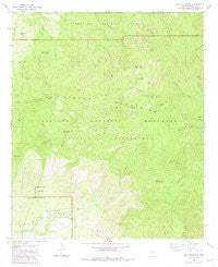
~ Mica Mountain AZ topo map, 1:24000 scale, 7.5 X 7.5 Minute, Historical, 1981, updated 1985
Mica Mountain, Arizona, USGS topographic map dated 1981.
Includes geographic coordinates (latitude and longitude). This topographic map is suitable for hiking, camping, and exploring, or framing it as a wall map.
Printed on-demand using high resolution imagery, on heavy weight and acid free paper, or alternatively on a variety of synthetic materials.
Topos available on paper, Waterproof, Poly, or Tyvek. Usually shipping rolled, unless combined with other folded maps in one order.
- Product Number: USGS-5553870
- Free digital map download (high-resolution, GeoPDF): Mica Mountain, Arizona (file size: 12 MB)
- Map Size: please refer to the dimensions of the GeoPDF map above
- Weight (paper map): ca. 55 grams
- Map Type: POD USGS Topographic Map
- Map Series: HTMC
- Map Verison: Historical
- Cell ID: 29031
- Scan ID: 312342
- Imprint Year: 1985
- Woodland Tint: Yes
- Aerial Photo Year: 1975
- Edit Year: 1981
- Field Check Year: 1976
- Datum: NAD27
- Map Projection: Transverse Mercator
- Map published by United States Geological Survey
- Map Language: English
- Scanner Resolution: 600 dpi
- Map Cell Name: Mica Mountain
- Grid size: 7.5 X 7.5 Minute
- Date on map: 1981
- Map Scale: 1:24000
- Geographical region: Arizona, United States
Neighboring Maps:
All neighboring USGS topo maps are available for sale online at a variety of scales.
Spatial coverage:
Topo map Mica Mountain, Arizona, covers the geographical area associated the following places:
- Duckbill - Turtle Spring - Grass Shack Spring - Happy Valley Lookout - Madrona Canyon - Devils Bathtub - Chimenea Canyon - Saguaro National Park East Unit (historical) - Wasp Spring - Cow Head Saddle - Reef Rock - X 9 Ranch - Douglas Camp Spring - Chimenea Natural Area - Madrona Ranger Station - Cow Head Trail Spring - Douglas Spring Trail - Mica Meadow - Deer Head Spring - Mica Mountain - Douglas Spring Campground - Man Head - Anillo Tank - Heartbreak Ridge Trail - Happy Valley Saddle - Sycamore Creek - Rincon Mountains - Mule Deer Tank - Italian Spring - Spud Rock - Arts Spring - Spud Rock Spring - Spud Rock Cabin - Manning Camp - Turkey Creek Spring - Head Trails Springs - Helens Dome - Tanque Verde Ridge - Saguaro National Park
- Map Area ID: AREA32.2532.125-110.625-110.5
- Northwest corner Lat/Long code: USGSNW32.25-110.625
- Northeast corner Lat/Long code: USGSNE32.25-110.5
- Southwest corner Lat/Long code: USGSSW32.125-110.625
- Southeast corner Lat/Long code: USGSSE32.125-110.5
- Northern map edge Latitude: 32.25
- Southern map edge Latitude: 32.125
- Western map edge Longitude: -110.625
- Eastern map edge Longitude: -110.5


