
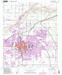
~ Mesa AZ topo map, 1:24000 scale, 7.5 X 7.5 Minute, Historical, 1952, updated 1983
Mesa, Arizona, USGS topographic map dated 1952.
Includes geographic coordinates (latitude and longitude). This topographic map is suitable for hiking, camping, and exploring, or framing it as a wall map.
Printed on-demand using high resolution imagery, on heavy weight and acid free paper, or alternatively on a variety of synthetic materials.
Topos available on paper, Waterproof, Poly, or Tyvek. Usually shipping rolled, unless combined with other folded maps in one order.
- Product Number: USGS-5553840
- Free digital map download (high-resolution, GeoPDF): Mesa, Arizona (file size: 12 MB)
- Map Size: please refer to the dimensions of the GeoPDF map above
- Weight (paper map): ca. 55 grams
- Map Type: POD USGS Topographic Map
- Map Series: HTMC
- Map Verison: Historical
- Cell ID: 28898
- Scan ID: 312319
- Imprint Year: 1983
- Woodland Tint: Yes
- Visual Version Number: 1
- Photo Revision Year: 1982
- Aerial Photo Year: 1978
- Edit Year: 1982
- Field Check Year: 1952
- Datum: NAD27
- Map Projection: Polyconic
- Map published by United States Geological Survey
- Map published by United States Army Corps of Engineers
- Map Language: English
- Scanner Resolution: 600 dpi
- Map Cell Name: Mesa
- Grid size: 7.5 X 7.5 Minute
- Date on map: 1952
- Map Scale: 1:24000
- Geographical region: Arizona, United States
Neighboring Maps:
All neighboring USGS topo maps are available for sale online at a variety of scales.
Spatial coverage:
Topo map Mesa, Arizona, covers the geographical area associated the following places:
- Apache West Mobile Village - Mesa Village Mobile Home Park - Woodland Heights - West Mesa Trailer Court - Windsor Mobile Home Park - Coronado Mobile Home Park - Mesa Patios - Alma Meadows Mobile Home Park - Brentwood West Mobile Home Park - Cypress Estates - Paradise Palms Trailer Resorts - Wintercone Park - Beverly Trailer Park - Sunrise Vista Mobile Home Park - Rancho de Arboleda - Venture Out Recreational Vehicle Resort - Woodside - Kay-Bee Mobile Villa - Sunview - Hohokam Village - Salt River - Woodridge Lakes - Lazona Trailer Court - Lehi - Mesa Grande Trailer Ranch - Golden West Estates - Garden Spot Mobile Home Park - Meadowvale - Homestead - Country Cousins Mobile Mecca - Conquistador Mobile Home Park - Seyenne Vista Mobile Home Park - Deserama Mobile Ranch - Keats Crossing - Summerplace Green - Brentwood West - Woodbridge Crossing - Kingsgate - Mesa Travelodge Mobile Home Park - Brentwood Mobile Manor - Los Maderas - Citrus Grove Trailer Court - Mesa Gardens Mobile Home Park - Southern Palms Trailer Park - El Mirage Mobile Home Park - Bonds Trailer Park - Sundial Mobile Park - Holiday Village Mobile Home Park - Eastway Mobile Home Park - M and M Mobile Village - Summer Place Trails - Woodcreek - Ambassador Downs Mobile Home Park - Summer Place Village - Trail Riders Holiday Park - Mesa - Castillo Nuevo Mobile Home Park - El Mirage - Suntree - McQueen - Suntrails - Karmella Mobile Home Park - Hawaiian Village Mobile Home Park - Knoell Mesa - Palm Gardens Mobile Home Manor - Parkview Mesa - Fuller Ranch - Country Club Village Mobile Home Park - Alma Gardens - El Mar Trailer Court - MonDak Mobile Home Park - La Casita Mobile Park - Suncrest Villas Mesa - Imperial Mobile Home Park - Sagewood - Holiday Village Mobile Home Park
- Map Area ID: AREA33.533.375-111.875-111.75
- Northwest corner Lat/Long code: USGSNW33.5-111.875
- Northeast corner Lat/Long code: USGSNE33.5-111.75
- Southwest corner Lat/Long code: USGSSW33.375-111.875
- Southeast corner Lat/Long code: USGSSE33.375-111.75
- Northern map edge Latitude: 33.5
- Southern map edge Latitude: 33.375
- Western map edge Longitude: -111.875
- Eastern map edge Longitude: -111.75


