
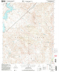
~ Maverick Mountain AZ topo map, 1:24000 scale, 7.5 X 7.5 Minute, Historical, 2004, updated 2007
Maverick Mountain, Arizona, USGS topographic map dated 2004.
Includes geographic coordinates (latitude and longitude). This topographic map is suitable for hiking, camping, and exploring, or framing it as a wall map.
Printed on-demand using high resolution imagery, on heavy weight and acid free paper, or alternatively on a variety of synthetic materials.
Topos available on paper, Waterproof, Poly, or Tyvek. Usually shipping rolled, unless combined with other folded maps in one order.
- Product Number: USGS-5553700
- Free digital map download (high-resolution, GeoPDF): Maverick Mountain, Arizona (file size: 15 MB)
- Map Size: please refer to the dimensions of the GeoPDF map above
- Weight (paper map): ca. 55 grams
- Map Type: POD USGS Topographic Map
- Map Series: HTMC
- Map Verison: Historical
- Cell ID: 28071
- Scan ID: 312256
- Imprint Year: 2007
- Woodland Tint: Yes
- Aerial Photo Year: 2003
- Edit Year: 2004
- Datum: NAD83
- Map Projection: Universal Transverse Mercator
- Map published by United States Geological Survey
- Map published by United States Forest Service
- Map Language: English
- Scanner Resolution: 600 dpi
- Map Cell Name: Maverick Mountain
- Grid size: 7.5 X 7.5 Minute
- Date on map: 2004
- Map Scale: 1:24000
- Geographical region: Arizona, United States
Neighboring Maps:
All neighboring USGS topo maps are available for sale online at a variety of scales.
Spatial coverage:
Topo map Maverick Mountain, Arizona, covers the geographical area associated the following places:
- Otero Tank - Carlock Tank - Indian Spring Peak - SB Cove Administrative Site - Panic Rock - Sycamore Spring - Indian Spring - Otero Spring - Ryan Tank - Alder Creek - Log Corral Wash - Pine Creek - Granite Mountain - Chinatown Spring - Maverick Spring Canyon - Little Granite Mountain - Log Corral Canyon - West Granite Mountain - Sandstone Spring - Round Butte - Summit Spring - Maverick Mountain Wash - Indian Springs Tank - Brush Corral Canyon - Red Mountain - Diamond Spring - Maverick Spring - Cottonwood Tank - Indian Point - Maverick Mountain - Cottonwood Basin - Indian Springs Canyon - Rock Spring - Dos S Ranch - Quartz Tank - Alder Point - Yellow Jacket Spring - Log Corral Spring - Brush Corral Spring - Hog Island - Round Valley - Camp Creek
- Map Area ID: AREA33.87533.75-111.625-111.5
- Northwest corner Lat/Long code: USGSNW33.875-111.625
- Northeast corner Lat/Long code: USGSNE33.875-111.5
- Southwest corner Lat/Long code: USGSSW33.75-111.625
- Southeast corner Lat/Long code: USGSSE33.75-111.5
- Northern map edge Latitude: 33.875
- Southern map edge Latitude: 33.75
- Western map edge Longitude: -111.625
- Eastern map edge Longitude: -111.5


