
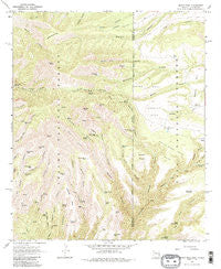
~ Maple Peak AZ topo map, 1:24000 scale, 7.5 X 7.5 Minute, Historical, 1967, updated 1985
Maple Peak, Arizona, USGS topographic map dated 1967.
Includes geographic coordinates (latitude and longitude). This topographic map is suitable for hiking, camping, and exploring, or framing it as a wall map.
Printed on-demand using high resolution imagery, on heavy weight and acid free paper, or alternatively on a variety of synthetic materials.
Topos available on paper, Waterproof, Poly, or Tyvek. Usually shipping rolled, unless combined with other folded maps in one order.
- Product Number: USGS-5553636
- Free digital map download (high-resolution, GeoPDF): Maple Peak, Arizona (file size: 15 MB)
- Map Size: please refer to the dimensions of the GeoPDF map above
- Weight (paper map): ca. 55 grams
- Map Type: POD USGS Topographic Map
- Map Series: HTMC
- Map Verison: Historical
- Cell ID: 27591
- Scan ID: 312220
- Imprint Year: 1985
- Woodland Tint: Yes
- Visual Version Number: 1
- Aerial Photo Year: 1966
- Field Check Year: 1967
- Datum: NAD27
- Map Projection: Polyconic
- Map published by United States Geological Survey
- Map Language: English
- Scanner Resolution: 600 dpi
- Map Cell Name: Maple Peak
- Grid size: 7.5 X 7.5 Minute
- Date on map: 1967
- Map Scale: 1:24000
- Geographical region: Arizona, United States
Neighboring Maps:
All neighboring USGS topo maps are available for sale online at a variety of scales.
Spatial coverage:
Topo map Maple Peak, Arizona, covers the geographical area associated the following places:
- Cookstove Corral - Horse Canyon Trail Thirty-six - Deer Spring - Wildbunch Trailhead - Porky Canyon Spring - Liza Tank - Maple Peak Tank - Nine Tank - Gavilan Number One Spring - Upper Oak Spring - Short Tank - Anderson Tank - Hells Hole Tank - Gavilan Corral - Copperas Tank - Apple Orchard Spring - Powerline Tank - Charlie Moore Mountain - Hogwallow Spring - Coalson Ranch - Morris Spring - Clear Spring - Buzzard Branch Tank - One Horn Canyon - Indian Spring - Copperas Spring - North Side Pine Corral - Charlie Moore Trailhead - Day Tank - Blue Tank - Webster Hole Tank - Snare Spring - Morris Gap Corral - Tributary Spring - Bullard Spring - Webster Canyon - Do Nothing Canyon - Citizen Spring - Stateline Water Storage Tank - Devils Den Canyon - Coalson Mesa - Indian Creek Spring - Banjo Two Tank - Coalson Tank - East Snare SPring - Vigil Tank - Hobo Number Two Tank - Coalson Spring - Sluefoot Blue Tank - South Buzzard Tank - Smoothing Iron Mesa - Gavilan Canyon - High Tank - W H Draw - Smoothing Iron Camp - Maple Spring - North Side Pine Tank - Heifers Delight Canyon - Juniper Mesa Tank - Pop Top Spring - Buchanan Tank - Pen Canyon Springs - Lower Indian Corral - Lower Oak Spring - Webster Mountain - Do Nothing Tank - Fox Corral - Pot Tank - Salt Ground Tank - Upper Pine Spring - Arizona Spring - J Lazy H Mesa - Gavilan Peak - Maple Corral - Cement Tank - Bullard Canyon - Bullard Peak - Skeleton Canyon - Bear Spring - One Horn Canyon - Lower Pine Spring - Wavy Spring - Brand Tree Canyon Tank - Cookstove Tank - Center Tank - Devils Den Canyon - Maple Peak - Angel Tank - Webster Mesa - Petmaker Canyon - Rattlesnake Canyon - Upper Oak Spring - Oak Spring - Snare Mesa Tank - Little Buzzard Tank - Rattlesnake Spring - Stacy Spring - Smoothing Iron Tank - Snare Mesa - Oak Springs Canyon
- Map Area ID: AREA33.37533.25-109.125-109
- Northwest corner Lat/Long code: USGSNW33.375-109.125
- Northeast corner Lat/Long code: USGSNE33.375-109
- Southwest corner Lat/Long code: USGSSW33.25-109.125
- Southeast corner Lat/Long code: USGSSE33.25-109
- Northern map edge Latitude: 33.375
- Southern map edge Latitude: 33.25
- Western map edge Longitude: -109.125
- Eastern map edge Longitude: -109


