
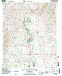
~ Kayler Butte AZ topo map, 1:24000 scale, 7.5 X 7.5 Minute, Historical, 2004, updated 2006
Kayler Butte, Arizona, USGS topographic map dated 2004.
Includes geographic coordinates (latitude and longitude). This topographic map is suitable for hiking, camping, and exploring, or framing it as a wall map.
Printed on-demand using high resolution imagery, on heavy weight and acid free paper, or alternatively on a variety of synthetic materials.
Topos available on paper, Waterproof, Poly, or Tyvek. Usually shipping rolled, unless combined with other folded maps in one order.
- Product Number: USGS-5553112
- Free digital map download (high-resolution, GeoPDF): Kayler Butte, Arizona (file size: 14 MB)
- Map Size: please refer to the dimensions of the GeoPDF map above
- Weight (paper map): ca. 55 grams
- Map Type: POD USGS Topographic Map
- Map Series: HTMC
- Map Verison: Historical
- Cell ID: 23101
- Scan ID: 311952
- Imprint Year: 2006
- Woodland Tint: Yes
- Aerial Photo Year: 2003
- Edit Year: 2004
- Datum: NAD83
- Map Projection: Universal Transverse Mercator
- Map published by United States Geological Survey
- Map published by United States Forest Service
- Map Language: English
- Scanner Resolution: 600 dpi
- Map Cell Name: Kayler Butte
- Grid size: 7.5 X 7.5 Minute
- Date on map: 2004
- Map Scale: 1:24000
- Geographical region: Arizona, United States
Neighboring Maps:
All neighboring USGS topo maps are available for sale online at a variety of scales.
Spatial coverage:
Topo map Kayler Butte, Arizona, covers the geographical area associated the following places:
- Oak Spring Canyon - Hardt Creek - H Four Tank - Chinaberry Spring - Tonto Basin Post Office - Cottonwood Creek - Kayler Spring - Gun Creek - Slate Creek - Daniels Spring - Cottonwood Spring - Point of Rock Spring - Haystack Tank - Bootlegger Spring - Dipper Spring - Gold Creek Tank - Hackberry Basin Spring - Reed Gulch - Gold Creek - Buena Vista Spring - Packard Wash - Old Fort Reno - Oak Spring - Sheep Tank - Ash Spring - Tonto Basin Fire District Station 1 - H Four Cemetery - Reed Spring - Hackberry Basin - Felton Spring - Kayler Butte - Haufner Spring - Haystack Butte - Water Wheel Spring - Buena Vista Creek - Horse Canyon - Punkin Center Baptist Church - Brunson Ranch - Mesa Tank - Moore Ranch - Gun Tank - Buena Vista Spring - Haufer Research Natural Area - Mesa Well - Oak Spring - Quartz Ledge Tank - Sycamore Canyon - Midway Tank - Haufer Wash - Quartz Ledge Canyon - Tonto Basin
- Map Area ID: AREA3433.875-111.375-111.25
- Northwest corner Lat/Long code: USGSNW34-111.375
- Northeast corner Lat/Long code: USGSNE34-111.25
- Southwest corner Lat/Long code: USGSSW33.875-111.375
- Southeast corner Lat/Long code: USGSSE33.875-111.25
- Northern map edge Latitude: 34
- Southern map edge Latitude: 33.875
- Western map edge Longitude: -111.375
- Eastern map edge Longitude: -111.25


