
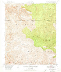
~ Iron Mountain AZ topo map, 1:24000 scale, 7.5 X 7.5 Minute, Historical, 1948, updated 1973
Iron Mountain, Arizona, USGS topographic map dated 1948.
Includes geographic coordinates (latitude and longitude). This topographic map is suitable for hiking, camping, and exploring, or framing it as a wall map.
Printed on-demand using high resolution imagery, on heavy weight and acid free paper, or alternatively on a variety of synthetic materials.
Topos available on paper, Waterproof, Poly, or Tyvek. Usually shipping rolled, unless combined with other folded maps in one order.
- Product Number: USGS-5552998
- Free digital map download (high-resolution, GeoPDF): Iron Mountain, Arizona (file size: 16 MB)
- Map Size: please refer to the dimensions of the GeoPDF map above
- Weight (paper map): ca. 55 grams
- Map Type: POD USGS Topographic Map
- Map Series: HTMC
- Map Verison: Historical
- Cell ID: 22064
- Scan ID: 311894
- Imprint Year: 1973
- Woodland Tint: Yes
- Aerial Photo Year: 1945
- Field Check Year: 1948
- Datum: NAD27
- Map Projection: Polyconic
- Map published by United States Geological Survey
- Map published by United States Army Corps of Engineers
- Map Language: English
- Scanner Resolution: 600 dpi
- Map Cell Name: Iron Mountain
- Grid size: 7.5 X 7.5 Minute
- Date on map: 1948
- Map Scale: 1:24000
- Geographical region: Arizona, United States
Neighboring Maps:
All neighboring USGS topo maps are available for sale online at a variety of scales.
Spatial coverage:
Topo map Iron Mountain, Arizona, covers the geographical area associated the following places:
- Cimeron Spring - Park Spring - Mullin Spring - J F Ranch Trail - Valles Well Number Two - Hackberry Butte - La Barge Mountain - Maverick Camp - Log Trough Spring - Swede Camp Spring - Whetrock Canyon - J F Ranch - Crockett Spring - Rogers Trailhead - Montana Mountain - Angel Spring - Superstition Wilderness - Mesquite Spring - Crockett Spring - Hole Spring - Reavis Saddle Spring - Tortilla Camp Trail - Randolph Spring - Rogers Canyon Spring - Woodbury Trailhead - Cimeron Mountain - Honeycutt Spring - Rogers Canyon - Reevis Trail - Upper Campaign Spring - Spencer Spring - Angel Basin - Red Wood Spring - Cottonwood Well - Turney Spring - Goat Canyon - Log Trough Canyon - Goldwater Tank - Bear Spring Number One - Mound Mountain - Iron Mountain - Iron Mountain Spring - Rogers Spring - Walnut Spring - Paradise Canyon - Black Jack Spring - White Mountain - Woodbury Cabin - Deer Spring - Rogers Troughs - Tortilla Pass - Whetstone Spring - New Spring - Little Goat Canyon - La Barge Mountain - Frog Spring - Musk Hog Spring - Reavis Ranch - Whiskey Spring - Pope Spring - Reevis Trail - Hackberry Canyon - Rattlesnake Spring - Eagle Spring - Rough Canyon - Pinto Spring Trough - Reevis Grave - Silver Spur Cabin - Pointer Spring - Willow Creek - Mountain Spring - Reevis Ranch - Black Spring - Hackberry Spring - Maverick Spring
- Map Area ID: AREA33.533.375-111.25-111.125
- Northwest corner Lat/Long code: USGSNW33.5-111.25
- Northeast corner Lat/Long code: USGSNE33.5-111.125
- Southwest corner Lat/Long code: USGSSW33.375-111.25
- Southeast corner Lat/Long code: USGSSE33.375-111.125
- Northern map edge Latitude: 33.5
- Southern map edge Latitude: 33.375
- Western map edge Longitude: -111.25
- Eastern map edge Longitude: -111.125


