
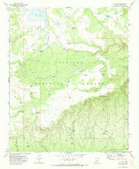
~ Hay Lake AZ topo map, 1:24000 scale, 7.5 X 7.5 Minute, Historical, 1970, updated 1973
Hay Lake, Arizona, USGS topographic map dated 1970.
Includes geographic coordinates (latitude and longitude). This topographic map is suitable for hiking, camping, and exploring, or framing it as a wall map.
Printed on-demand using high resolution imagery, on heavy weight and acid free paper, or alternatively on a variety of synthetic materials.
Topos available on paper, Waterproof, Poly, or Tyvek. Usually shipping rolled, unless combined with other folded maps in one order.
- Product Number: USGS-5552606
- Free digital map download (high-resolution, GeoPDF): Hay Lake, Arizona (file size: 9 MB)
- Map Size: please refer to the dimensions of the GeoPDF map above
- Weight (paper map): ca. 55 grams
- Map Type: POD USGS Topographic Map
- Map Series: HTMC
- Map Verison: Historical
- Cell ID: 19759
- Scan ID: 311694
- Imprint Year: 1973
- Woodland Tint: Yes
- Aerial Photo Year: 1968
- Field Check Year: 1970
- Datum: NAD27
- Map Projection: Transverse Mercator
- Map published by United States Geological Survey
- Map Language: English
- Scanner Resolution: 600 dpi
- Map Cell Name: Hay Lake
- Grid size: 7.5 X 7.5 Minute
- Date on map: 1970
- Map Scale: 1:24000
- Geographical region: Arizona, United States
Neighboring Maps:
All neighboring USGS topo maps are available for sale online at a variety of scales.
Spatial coverage:
Topo map Hay Lake, Arizona, covers the geographical area associated the following places:
- PW Tank - Pieper Tank - Mesa Tank - Plantation Tank - Duke Tank Number Two - Natural Tank - Boulder Tank - Hay Lake Dam - Kens Tank - Big Rock Tank - Sixteen Tank - Buck Tank - Daze Tank - Thistle Tank - Limestone Tank - Woods Tank - Duke Tank Number One - Yellow Jacket Draw - Sha Donde Tank - Hide Tank - Sha Donde Tank - Fourteen Tank - Fish and Game - Freight Trail Tank - Green Tank - Hay Lake - Judy Tank - Coyote Tank - Tiny Tank - Chilson Tank - Fisher Tank Number One - Y-seven Tank - Chilson Canal - Cowhead Tank - Melatone Tank - Dogie Tank - Daze Lake - Fisher Tank Number Two - Janice Tank - Blue Ridge Ranger District - Bawcom Tank - Green Howard Tank - Hide Tank
- Map Area ID: AREA34.7534.625-111.25-111.125
- Northwest corner Lat/Long code: USGSNW34.75-111.25
- Northeast corner Lat/Long code: USGSNE34.75-111.125
- Southwest corner Lat/Long code: USGSSW34.625-111.25
- Southeast corner Lat/Long code: USGSSE34.625-111.125
- Northern map edge Latitude: 34.75
- Southern map edge Latitude: 34.625
- Western map edge Longitude: -111.25
- Eastern map edge Longitude: -111.125


