
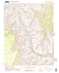
~ Havasupai Point AZ topo map, 1:24000 scale, 7.5 X 7.5 Minute, Historical, 1988, updated 1988
Havasupai Point, Arizona, USGS topographic map dated 1988.
Includes geographic coordinates (latitude and longitude). This topographic map is suitable for hiking, camping, and exploring, or framing it as a wall map.
Printed on-demand using high resolution imagery, on heavy weight and acid free paper, or alternatively on a variety of synthetic materials.
Topos available on paper, Waterproof, Poly, or Tyvek. Usually shipping rolled, unless combined with other folded maps in one order.
- Product Number: USGS-5552590
- Free digital map download (high-resolution, GeoPDF): Havasupai Point, Arizona (file size: 16 MB)
- Map Size: please refer to the dimensions of the GeoPDF map above
- Weight (paper map): ca. 55 grams
- Map Type: POD USGS Topographic Map
- Map Series: HTMC
- Map Verison: Historical
- Cell ID: 19684
- Scan ID: 311686
- Imprint Year: 1988
- Woodland Tint: Yes
- Visual Version Number: 2
- Aerial Photo Year: 1982
- Edit Year: 1988
- Field Check Year: 1985
- Datum: NAD27
- Map Projection: Transverse Mercator
- Provisional map: Yes
- Map published by United States Geological Survey
- Map Language: English
- Scanner Resolution: 600 dpi
- Map Cell Name: Havasupai Point
- Grid size: 7.5 X 7.5 Minute
- Date on map: 1988
- Map Scale: 1:24000
- Geographical region: Arizona, United States
Neighboring Maps:
All neighboring USGS topo maps are available for sale online at a variety of scales.
Spatial coverage:
Topo map Havasupai Point, Arizona, covers the geographical area associated the following places:
- Turquoise Canyon - Willies Necktie Rapids - Ruby Rapids - Castor Temple - Shinumo Creek - Scylla Butte - Signal Hill - Agate Rapids - Emerald Canyon - Dox Castle - Emerald Rapid - Charybdis Butte - Shaler Plateau - Sagittarius Ridge - Grand Scenic Divide - Serpentine Canyon - Burro Canyon - Evans Butte - Point Sublime - Gawain Abyss - Scorpion Ridge - Fossil Mountain - Copper Canyon - Walapai Point - Serpentine Rapids - Le Conte Plateau - Havasupai Point - Bass Rapids - Agate Canyon - Sapphire Rapids - Monadnock Amphitheater - Ruby Canyon - Sapphire Canyon - Kanabownits Canyon - Tuna Creek - Shinumo Rapids - Hotauta Amphitheater - Geikie Peak - Wallace Butte - Huxley Terrace - Tyndall Dome - Bass Canyon - Hotauta Canyon - Flint Creek
- Map Area ID: AREA36.2536.125-112.375-112.25
- Northwest corner Lat/Long code: USGSNW36.25-112.375
- Northeast corner Lat/Long code: USGSNE36.25-112.25
- Southwest corner Lat/Long code: USGSSW36.125-112.375
- Southeast corner Lat/Long code: USGSSE36.125-112.25
- Northern map edge Latitude: 36.25
- Southern map edge Latitude: 36.125
- Western map edge Longitude: -112.375
- Eastern map edge Longitude: -112.25


