
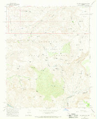
~ Hackberry Mtn AZ topo map, 1:24000 scale, 7.5 X 7.5 Minute, Historical, 1967, updated 1968
Hackberry Mtn , Arizona, USGS topographic map dated 1967.
Includes geographic coordinates (latitude and longitude). This topographic map is suitable for hiking, camping, and exploring, or framing it as a wall map.
Printed on-demand using high resolution imagery, on heavy weight and acid free paper, or alternatively on a variety of synthetic materials.
Topos available on paper, Waterproof, Poly, or Tyvek. Usually shipping rolled, unless combined with other folded maps in one order.
- Product Number: USGS-5552478
- Free digital map download (high-resolution, GeoPDF): Hackberry Mtn , Arizona (file size: 10 MB)
- Map Size: please refer to the dimensions of the GeoPDF map above
- Weight (paper map): ca. 55 grams
- Map Type: POD USGS Topographic Map
- Map Series: HTMC
- Map Verison: Historical
- Cell ID: 18852
- Scan ID: 311632
- Imprint Year: 1968
- Woodland Tint: Yes
- Aerial Photo Year: 1965
- Field Check Year: 1967
- Datum: NAD27
- Map Projection: Polyconic
- Map published by United States Geological Survey
- Map Language: English
- Scanner Resolution: 600 dpi
- Map Cell Name: Hackberry Mountain
- Grid size: 7.5 X 7.5 Minute
- Date on map: 1967
- Map Scale: 1:24000
- Geographical region: Arizona, United States
Neighboring Maps:
All neighboring USGS topo maps are available for sale online at a variety of scales.
Spatial coverage:
Topo map Hackberry Mtn , Arizona, covers the geographical area associated the following places:
- Goodenough Tank - Partnership Tank - Crissman Spring - Dollar More Tank - Cimarron Spring - Willow Tank - Tunnel Tank - Sally May Wash - Potholes Tank - Towel Creek Trail - Pambo Tank - Buckhead Tank - Buzzard Tank - Cottonwood Well - High Saddle - Sierra Tank - Little Buckskin Tank - Myrtle Tank - Burnt Spring - Rim Tank - Cimarron Saddle - Towel Spring - Louthan Tank - Hackberry Basin - Cedar Flat Tank - Jims Tank Number Two - Viede Tank - Buckskin Tank - Sally May Tank - Buck Tank - Hogback Tank - Towel Peaks Tank - Eds Tank - Sycamore Tank - Sycamore Spring - Rock Tank - Brushy Prong - Eds Point Spring - Mescal Tank - Hackberry Canyon - Wet Prong Spring - Hackberry Springs - Nine and a Half Mile Tank - Towel Peaks - Bull Run Tank - Wire Corral Tank - Walts Tank - Cimarron Creek - Eds Point Tank - Sob Tank - Tenmile Tank - Pothole Tank - Cimarron Tank - Sycamore Basin Tank - Mud Tanks Mesa - Buckskin Hills - Phroney Spring - Cedar Spring - Doeskin Tank - Dorens Defeat Spring - Peaches Tank - Trail Tank - Pequeño Tank - Daveys Tank - Hackberry Mountain - Verde Scenic River Area - Needed Tank - Sheep Corral Tank - Needle Rock - Sycamore Basin - Dorens Defeat Tank - Childs - Fossil Pocket - Sally May Spring - Sycamore Buttes - Deadman Mesa - Kiki Tank - Doe Tank - Deer Basin - Willow Spring - Mud Tanks Trail Fifty - Towel Tank - Towel Creek Trail - The Basin - Boulder Canyon - Chalk Spring - Dorens Defeat Canyon - Eds Point - Cimarron Hills - Holdup Tank - The Rocks
- Map Area ID: AREA34.534.375-111.75-111.625
- Northwest corner Lat/Long code: USGSNW34.5-111.75
- Northeast corner Lat/Long code: USGSNE34.5-111.625
- Southwest corner Lat/Long code: USGSSW34.375-111.75
- Southeast corner Lat/Long code: USGSSE34.375-111.625
- Northern map edge Latitude: 34.5
- Southern map edge Latitude: 34.375
- Western map edge Longitude: -111.75
- Eastern map edge Longitude: -111.625


