
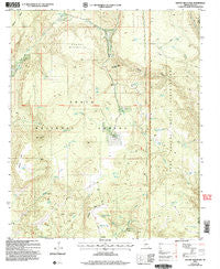
~ Gentry Mountain AZ topo map, 1:24000 scale, 7.5 X 7.5 Minute, Historical, 2004, updated 2006
Gentry Mountain, Arizona, USGS topographic map dated 2004.
Includes geographic coordinates (latitude and longitude). This topographic map is suitable for hiking, camping, and exploring, or framing it as a wall map.
Printed on-demand using high resolution imagery, on heavy weight and acid free paper, or alternatively on a variety of synthetic materials.
Topos available on paper, Waterproof, Poly, or Tyvek. Usually shipping rolled, unless combined with other folded maps in one order.
- Product Number: USGS-5552134
- Free digital map download (high-resolution, GeoPDF): Gentry Mountain, Arizona (file size: 12 MB)
- Map Size: please refer to the dimensions of the GeoPDF map above
- Weight (paper map): ca. 55 grams
- Map Type: POD USGS Topographic Map
- Map Series: HTMC
- Map Verison: Historical
- Cell ID: 17062
- Scan ID: 311457
- Imprint Year: 2006
- Woodland Tint: Yes
- Aerial Photo Year: 2003
- Edit Year: 2004
- Survey Year: 1958
- Datum: NAD83
- Map Projection: Universal Transverse Mercator
- Map published by United States Geological Survey
- Map published by United States Forest Service
- Map Language: English
- Scanner Resolution: 600 dpi
- Map Cell Name: Gentry Mountain
- Grid size: 7.5 X 7.5 Minute
- Date on map: 2004
- Map Scale: 1:24000
- Geographical region: Arizona, United States
Neighboring Maps:
All neighboring USGS topo maps are available for sale online at a variety of scales.
Spatial coverage:
Topo map Gentry Mountain, Arizona, covers the geographical area associated the following places:
- Vosburg Tank - Walnut Spring - Q Ranch - Joes Spring - Wolf Spring - Reservation Tank - Shell Mountain - West Prong Gentry Creek - Middleton Mesa - Pine Spring - Catholic Peak - Maxwell Tank - Charles Williams Spring - Whiskey Tank - Trail Tank - Gentry Creek - Lower Bell Tank - Middleton Mesa Tank - Brewer Spring - Ed Spring - Pine Spring - Shell Mountain Tank - Ellison Creek Tank - Clover Flat Tank Number 2 - Allen Tank - Cunningham Spring - Flying V Ranch - Bill Spring - Gentry Tank - Boundary Tank - Stone Tank - Vosburg Mesa - Deer Tank - Gentry Tank - Mud Spring - Clover Flat Tank - Gentry Canyon Spring - Mud Tank - Gentry Mesa Tank - Ashurst Creek - Catholic Peak Tank - Gentry Mountain - Red Ledge Mesa Tank - Maxwell Spring - Turkey Spring - Upper Bell Tank - Windy Pass Tank
- Map Area ID: AREA34.12534-110.875-110.75
- Northwest corner Lat/Long code: USGSNW34.125-110.875
- Northeast corner Lat/Long code: USGSNE34.125-110.75
- Southwest corner Lat/Long code: USGSSW34-110.875
- Southeast corner Lat/Long code: USGSSE34-110.75
- Northern map edge Latitude: 34.125
- Southern map edge Latitude: 34
- Western map edge Longitude: -110.875
- Eastern map edge Longitude: -110.75


