
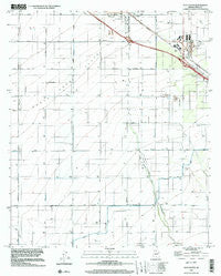
~ Eloy South AZ topo map, 1:24000 scale, 7.5 X 7.5 Minute, Historical, 1996, updated 2001
Eloy South, Arizona, USGS topographic map dated 1996.
Includes geographic coordinates (latitude and longitude). This topographic map is suitable for hiking, camping, and exploring, or framing it as a wall map.
Printed on-demand using high resolution imagery, on heavy weight and acid free paper, or alternatively on a variety of synthetic materials.
Topos available on paper, Waterproof, Poly, or Tyvek. Usually shipping rolled, unless combined with other folded maps in one order.
- Product Number: USGS-5551780
- Free digital map download (high-resolution, GeoPDF): Eloy South, Arizona (file size: 7 MB)
- Map Size: please refer to the dimensions of the GeoPDF map above
- Weight (paper map): ca. 55 grams
- Map Type: POD USGS Topographic Map
- Map Series: HTMC
- Map Verison: Historical
- Cell ID: 14213
- Scan ID: 311276
- Imprint Year: 2001
- Woodland Tint: Yes
- Aerial Photo Year: 1996
- Survey Year: 1976
- Datum: NAD83
- Map Projection: Universal Transverse Mercator
- Map published by United States Geological Survey
- Map Language: English
- Scanner Resolution: 600 dpi
- Map Cell Name: Eloy South
- Grid size: 7.5 X 7.5 Minute
- Date on map: 1996
- Map Scale: 1:24000
- Geographical region: Arizona, United States
Neighboring Maps:
All neighboring USGS topo maps are available for sale online at a variety of scales.
Spatial coverage:
Topo map Eloy South, Arizona, covers the geographical area associated the following places:
- Eloy Fire District Station 521 - Picacho Overpass - City of Eloy - Santa Cruz Flats - Curiel School Mini Park Site - Eds Field (historical) - Eloy Business Park - Eloy Division - Sunshine Boulevard Interchange - Santa Cruz River - KONZ-FM (Arizona City) - Junction State Route Eightyfour Interchange - Curiel Elementary School Annex - Central Main Canal - Westside Church of God in Christ - KKAF-FM (Eloy) - Eloy Memorial Park
- Map Area ID: AREA32.7532.625-111.625-111.5
- Northwest corner Lat/Long code: USGSNW32.75-111.625
- Northeast corner Lat/Long code: USGSNE32.75-111.5
- Southwest corner Lat/Long code: USGSSW32.625-111.625
- Southeast corner Lat/Long code: USGSSE32.625-111.5
- Northern map edge Latitude: 32.75
- Southern map edge Latitude: 32.625
- Western map edge Longitude: -111.625
- Eastern map edge Longitude: -111.5


