
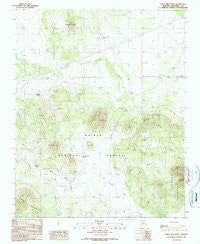
~ Ebert Mountain AZ topo map, 1:24000 scale, 7.5 X 7.5 Minute, Historical, 1989, updated 1990
Ebert Mountain, Arizona, USGS topographic map dated 1989.
Includes geographic coordinates (latitude and longitude). This topographic map is suitable for hiking, camping, and exploring, or framing it as a wall map.
Printed on-demand using high resolution imagery, on heavy weight and acid free paper, or alternatively on a variety of synthetic materials.
Topos available on paper, Waterproof, Poly, or Tyvek. Usually shipping rolled, unless combined with other folded maps in one order.
- Product Number: USGS-5551708
- Free digital map download (high-resolution, GeoPDF): Ebert Mountain, Arizona (file size: 10 MB)
- Map Size: please refer to the dimensions of the GeoPDF map above
- Weight (paper map): ca. 55 grams
- Map Type: POD USGS Topographic Map
- Map Series: HTMC
- Map Verison: Historical
- Cell ID: 13560
- Scan ID: 311240
- Imprint Year: 1990
- Woodland Tint: Yes
- Aerial Photo Year: 1986
- Edit Year: 1989
- Field Check Year: 1987
- Datum: NAD27
- Map Projection: Transverse Mercator
- Provisional map: Yes
- Map published by United States Geological Survey
- Map Language: English
- Scanner Resolution: 600 dpi
- Map Cell Name: Ebert Mountain
- Grid size: 7.5 X 7.5 Minute
- Date on map: 1989
- Map Scale: 1:24000
- Geographical region: Arizona, United States
Neighboring Maps:
All neighboring USGS topo maps are available for sale online at a variety of scales.
Spatial coverage:
Topo map Ebert Mountain, Arizona, covers the geographical area associated the following places:
- Pinyon Tank - Arizona Game and Fish TrickTank - Everett Guzzler - Dent and Sayer Tank - BS Tank - Nagiller Winter Camp - Hot Tank - Cinder Pit Tank - House Tank - Ebert Tank - Ida Tank - Ebert Guzzler - Platten Tank - Hibben Tank - Antelope Tank - Dog Knobs Trick Tank - Sheep Tank - Webster Tank - Wild Bill Tank - Dry Lake Tank - Red Mountain - Butcherknife Hill - Nagiller Corral and Scales - Nagiller Ranch (historical) - Ford Tank - Butcherknife Tank - Double Top - Dent and Sayer Ranch (historical) - Ebert Mountain - Salt Mine Substation
- Map Area ID: AREA35.62535.5-112-111.875
- Northwest corner Lat/Long code: USGSNW35.625-112
- Northeast corner Lat/Long code: USGSNE35.625-111.875
- Southwest corner Lat/Long code: USGSSW35.5-112
- Southeast corner Lat/Long code: USGSSE35.5-111.875
- Northern map edge Latitude: 35.625
- Southern map edge Latitude: 35.5
- Western map edge Longitude: -112
- Eastern map edge Longitude: -111.875


