
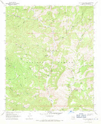
~ Dutch Blue Creek AZ topo map, 1:24000 scale, 7.5 X 7.5 Minute, Historical, 1967, updated 1971
Dutch Blue Creek, Arizona, USGS topographic map dated 1967.
Includes geographic coordinates (latitude and longitude). This topographic map is suitable for hiking, camping, and exploring, or framing it as a wall map.
Printed on-demand using high resolution imagery, on heavy weight and acid free paper, or alternatively on a variety of synthetic materials.
Topos available on paper, Waterproof, Poly, or Tyvek. Usually shipping rolled, unless combined with other folded maps in one order.
- Product Number: USGS-5551648
- Free digital map download (high-resolution, GeoPDF): Dutch Blue Creek, Arizona (file size: 13 MB)
- Map Size: please refer to the dimensions of the GeoPDF map above
- Weight (paper map): ca. 55 grams
- Map Type: POD USGS Topographic Map
- Map Series: HTMC
- Map Verison: Historical
- Cell ID: 13157
- Scan ID: 311210
- Imprint Year: 1971
- Woodland Tint: Yes
- Aerial Photo Year: 1966
- Field Check Year: 1967
- Datum: NAD27
- Map Projection: Polyconic
- Map published by United States Geological Survey
- Map Language: English
- Scanner Resolution: 600 dpi
- Map Cell Name: Dutch Blue Creek
- Grid size: 7.5 X 7.5 Minute
- Date on map: 1967
- Map Scale: 1:24000
- Geographical region: Arizona, United States
Neighboring Maps:
All neighboring USGS topo maps are available for sale online at a variety of scales.
Spatial coverage:
Topo map Dutch Blue Creek, Arizona, covers the geographical area associated the following places:
- White Rocks Cabin - Tornado Canyon - Hammerhead Spring - Bench Spring - Pasture Tank - Bull Creek - Hannah Spring Canyon Corral - Auger Canyon - Benton Tank - Bull Basin Corral - Salt Basin - Blue River One Hundred One Trail - Rousensock Creek - Auger Creek Spring - Squaw Creek - Winter Cabin Spring - Benton Creek Spring - Bear Trough Spring - H U Bar Ranch - Jack Rabbit Spring - Paint Rock Prairie - Ladrone Canyon - Ash Spring - Post Canyon - Auger Corral - Stray Horse Canyon Trail Twenty - Little Blue Box - North Bull Creek Tank - Bonehead Basin - Benton Creek - Lower Oak Creek Corral - Dutch Blue Creek - Syeamore Corral - Ash Creek - Beeler Creek Corral - Bull Spring - Thomas Creek - Bull Basin Spring - Smith Cabin - Strayhorse Creek - Horsehead Spring - Hobo Canyon - Owl Creek - Board Canyon - Zuni Basin - Hu Bar Spring - Government Mesa - Oak Creek - Latherone Spring - North Bull Creek - Hannah Hot Spring - Dead Mule Spring - VT Ranch - Bell Springs - Hannah Springs Creek - Mangrum Spring - Al Creek Corral - Yellow Springs - Auger Tank - H U Bar Box - Trap Corral - Shorty Spring - Alder Peak - Dutch Chimney Corral - Bonehead Spring - Winter Cabin - Little Dutch Spring - H U Bar Tank - Benton Falls Tank - Auger Creek - Ladron Spring - Beeler Creek - Yellow Spring - VT Pasture Tank - Rousensock Canyon - Sycamore Canyon
- Map Area ID: AREA33.533.375-109.25-109.125
- Northwest corner Lat/Long code: USGSNW33.5-109.25
- Northeast corner Lat/Long code: USGSNE33.5-109.125
- Southwest corner Lat/Long code: USGSSW33.375-109.25
- Southeast corner Lat/Long code: USGSSE33.375-109.125
- Northern map edge Latitude: 33.5
- Southern map edge Latitude: 33.375
- Western map edge Longitude: -109.25
- Eastern map edge Longitude: -109.125


